School Closures Nova Scotia: Winter Storm Watch & Potential Disruptions
A late-winter blast is set to impact Nova Scotia, with significant snowfall expected starting late Sunday afternoon and continuing into Tuesday morning. This has raised concerns about potential school closures across the province, and residents are urged to prepare for challenging travel conditions.
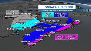
Snowfall Forecast & Timing
Environment Canada forecasts 10 to 15 cm of snow for much of Nova Scotia, beginning in the southwestern shore around Digby and extending to Halifax counties. The Halifax Regional Municipality is expected to see the heaviest snowfall Sunday evening and into Monday morning, with the possibility of intensification. Northern parts of the province may see snow arrive early Monday, reaching Cape Breton by mid-morning.
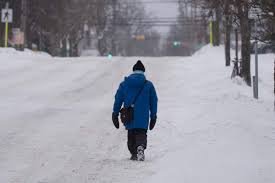
The snow is expected to be wet and heavy due to temperatures hovering near the freezing mark. This increases the risk of power outages due to the weight on trees and power lines. Residents are encouraged to report any outages to Nova Scotia Power: https://www.nspower.ca/
Potential for School Closures & Travel Disruptions
Given the anticipated snowfall, the possibility of school closures is high. School boards across Nova Scotia will be closely monitoring the weather conditions and making decisions based on student and staff safety. Parents and students are advised to check their school board’s website and social media channels for the latest updates. Here are some key links:
- Halifax Regional Centre for Education
- South Shore Regional Centre for Education
- Chignecto-Central Regional Centre for Education
Travel is expected to be significantly impacted. Reduced visibility due to heavy snowfall, combined with slippery road conditions, will make driving hazardous. Environment Canada cautions that visibility could be reduced to near zero at times. Motorists are urged to avoid unnecessary travel and, if driving is essential, to drive slowly and cautiously.
Newfoundland Also Braces for Impact
Newfoundland is also under winter storm watches, with potential snowfall amounts ranging from 20 to 50 cm, particularly in eastern regions. Strong wind gusts of 80 to 100 km/h are expected, further exacerbating travel difficulties. The snow in Newfoundland is expected to transition to ice pellets and freezing rain before turning to rain as temperatures rise.
Stay Informed
Stay up-to-date with the latest weather forecasts and warnings from Environment Canada: https://weather.gc.ca/. Monitor local news sources and school board websites for updates on school closures and travel advisories. Prioritize safety and take necessary precautions to protect yourself and your family during this winter storm.