Maui Flooding: Hawaii Grapples with Historic Storms and Dam Threat
Hawaii is currently battling devastating flooding as a series of powerful storms have unleashed torrential rain and damaging winds across the islands. Authorities are calling this the worst flooding the state has experienced in two decades, with homes washed away, roads severely damaged, and the looming threat of a dam failure adding to the crisis.
Emergency Evacuations and Dam Concerns
On March 20th, an emergency evacuation was ordered for thousands of residents in northern Oahu due to the precarious condition of a 120-year-old dam. While the dam hasn’t yet failed, the Hawaii Emergency Management Agency warned it was at “imminent risk of failure.” Evacuations were specifically ordered for Haleʻiwa and Waialua, with alerts emphasizing the potential for road collapses. The message was stark: “LEAVE NOW.”
Governor Josh Green confirmed that, thankfully, there have been no reported deaths or missing persons as a direct result of the flooding. However, he emphasized the severity of the situation, stating it’s the worst the state has seen since the early 2000s. Approximately 200 people have been rescued, and around 10 were treated for hypothermia in hospitals.
Ongoing Rainfall and Flash Flood Risk
The National Weather Service in Honolulu reported on March 21st that two weather systems continue to bring heavy rainfall – sometimes reaching 2 to 4 inches per hour – thunderstorms, and a heightened risk of flash flooding through the weekend. A flood watch remains in effect for the entire state through the afternoon of March 22nd.
Dam Details and Hazard Potential
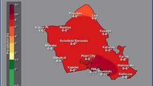
The at-risk dam is located in Central Oahu, near Schofield Barracks, off Kamehameha Highway. Oahu County has 13 dams in total, with seven classified as having “high” or “significant” hazard potential. The Wahiawa dam, a privately-owned irrigation dam built in 1906, is considered to be in poor condition and poses a high hazard. Water levels in the Kaukonahua Stream near Wailua surged over 10.5 feet on March 20th, exceeding levels recorded on March 13th.
Dramatic Rescue Operations and Infrastructure Damage
The impact of the flooding has been dramatic. On March 20th, a foot of water inundated a road near Waialua, swamping cars and homes. Rescuers were forced to use a bulldozer to transport stranded civilians to safety. A home on Kaihulo Drive in Mokuleia, near Waialua, was even swept onto the beach, appearing to be split in half. Furthermore, a section of road in Makaha Valley collapsed, sending vehicles over the edge.
Kona Lows: A Rare Weather Phenomenon
These storms are attributed to a winter weather pattern known as “kona lows” or “kona storms,” which impact the leeward sides of the islands. While one or two kona storms typically affect Hawaii each season (November-March), it’s exceptionally rare for two to occur within the same month, let alone the same week, according to AccuWeather meteorologists. The first round of storms hit between March 10th and 16th, delivering over 4 feet of rainfall in some areas.
Historical Context: The 2004 Manoa Flood
The current flooding is considered the worst since the 2004 Manoa Flood. That event, on October 30, 2004, involved rainfall peaking at 1.29 inches in 15 minutes and 8.71 inches in 6 hours, causing significant damage to the University of Hawaii at Manoa campus and surrounding residential areas. Damage from the 2004 flood reached approximately $85 million.
Potential Economic Impact
Governor Green estimates the damage from the current March 2024 flooding could reach a staggering $1 billion, impacting homes, roads, schools, airports, and even a hospital on Maui. The situation remains fluid, and ongoing monitoring and rescue efforts are crucial. You can find more information about flood preparedness and safety from the Federal Emergency Management Agency (FEMA).