Guatemala Volcano Alert: Fuego and Santiaguito Pose Explosion Risks
Guatemalan authorities have issued a heightened alert for the Fuego and Santiaguito volcanoes, two of the country’s most active, warning of potential “explosive activity.” The National Coordination for Disaster Reduction (Conred) in the Sacatepéquez department declared an orange alert, activating intervention plans and increasing surveillance of both volcanoes. This precedes a red alert, indicating a more critical situation.
Fuego Volcano: A Central American Hotspot
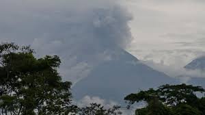
Fuego, towering at 3,763 meters (12,346 feet), is considered the most active volcano in Central America. Located just 35 kilometers (22 miles) from Guatemala City, its activity poses a significant risk to surrounding populations. In recent days, Fuego has been emitting plumes of ash, prompting the National Institute of Seismology, Volcanology, Meteorology and Hydrology (Insivumeh) to predict ash dispersion within a 15 to 40 kilometer (9 to 25 mile) radius, reaching altitudes of 4,300 to 4,800 meters (14,108 to 15,748 feet).
Insivumeh reports that Fuego’s activity is characterized by “recurrent explosions, weak to moderate to strong, with intervals of eight to twelve hours.” The devastating eruption of June 3, 2018, serves as a stark reminder of the volcano’s power, triggering a pyroclastic flow that obliterated the village of San Miguel Los Lotes, resulting in 215 fatalities and numerous missing persons. You can find more information about volcanic hazards at the US Geological Survey website.
Santiaguito Volcano: Constant Pyroclastic Flows
Santiaguito, reaching 2,500 meters (8,202 feet) in height, is located in the Quezaltenango department, 206 kilometers (128 miles) west of the capital. The volcano’s crater continues to eject lava, generating constant avalanches of short-range pyroclastic flows, primarily on its southwest, east, and northeast flanks. The most significant eruption in Santiaguito’s history occurred in 1929, claiming the lives of approximately 2,500 people.
Safety Measures and Warnings
Insivumeh has cautioned tourism agencies about the “dangers” of attempting ascents and staying in areas adjacent to the volcanoes. The Ministry of Agriculture has also issued warnings regarding the potential impact of ashfall on crops, livestock, and water sources. It’s crucial to stay updated with official alerts and heed the advice of local authorities.
Stay informed about the latest developments from official sources like Conred and Insivumeh.
Copyright © 1998-2024 – All rights reserved. A NumériQ production.