
Brace Yourself: Severe Thunderstorms Set to Hit Ontario
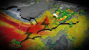
After a turbulent weekend that left Southern and Eastern Ontario reeling from at least two confirmed tornadoes near Woodstock and Lindsay, the atmosphere is charging up once again. Forecasters have issued a yellow warning – severe thunderstorm alert as a new weather system threatens to disrupt the start of the work week.
If you are in the affected regions, now is the time to stay vigilant. A potent low-pressure system is currently migrating into Ontario and southern Quebec, bringing with it a cold front that could trigger volatile weather conditions.
Where is the Risk Highest?
While not every city will feel the impact, specific zones are under higher alert. The primary areas of concern include:
- n
- Extreme Southwestern Ontario: High probability of storm development.
- The Greater Toronto Area (GTA): Risk peaks from late Monday afternoon into the evening, particularly along a lake-breeze boundary stretching from Lake Simcoe to Pickering and Oshawa.
- North and East of the GTA: Increased likelihood of isolated cells.
- Deep Eastern Ontario: Organized storm activity expected near the Ontario-Quebec border.
What to Expect: Wind, Hail, and Commute Chaos
This isn’t just a light drizzle. The severe thunderstorm risk comes with several dangerous elements that residents should prepare for:
- Dangerous Hail: In eastern Ontario, some hailstones could reach the size of ping-pong balls, posing a threat to vehicles and property.
- Powerful Wind Gusts: Strong winds are expected to accompany the storm fronts, potentially causing localized damage.
- Commuter Delays: With storms timing up with morning and evening rush hours, expect visibility issues and potential road hazards.
For real-time updates and official safety protocols, we strongly recommend monitoring Environment and Climate Change Canada, the gold standard for meteorological alerts in the region.
Looking Ahead: The Rest of the Week
Is there a break in sight? Yes, but it’s temporary. Here is the outlook for the coming days:
Tuesday: Forecasts suggest a relatively quiet day, providing a brief window of calm for residents to recover from Monday’s activity.
Wednesday: The pattern repeats. Another storm risk is expected to build across southwestern Ontario, though it may bring a welcome side effect: a dip in temperatures and a break from the oppressive humidity.
A Note on Air Quality
You may notice a hazy horizon throughout the week. This is due to drifting wildfire smoke. Fortunately, most of the smoke is expected to remain high in the atmosphere, meaning surface-level air quality should remain acceptable for most people.



