
Indianapolis Weather: A Quick Shift in Conditions with WTHR
Indianapolis residents, prepare for a dynamic weather week! A brief cooldown is upon us, bringing a chance of light accumulating snow overnight, potentially impacting Monday morning commutes. Following this, a warmer, yet more active pattern will usher in heavy rainfall starting Tuesday. Stay tuned to WTHR for the latest updates.
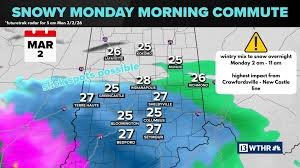
Cooler Temperatures & Overnight Snow
Temperatures have dipped, settling in the 30s today. While we’ll enjoy mostly dry conditions with a mix of sun and clouds, a quick-moving winter precipitation system is headed our way overnight. This system, closely monitored by the WTHR weather team, has shifted northward, targeting central Indiana.
The primary impact zone will stretch from Crawfordsville through Carmel to New Castle and points south. Expect a transition from a rain/sleet mix around 2 a.m. to all snow as temperatures fall overnight. While not a major snow event, localized snow bands could produce snowfall totals exceeding 2 inches. This timing is crucial, as it may create slick road conditions during the Monday morning commute.
Monday & Beyond: Melting Snow & Incoming Rain
The snow will wrap up by mid-morning Monday, with temperatures climbing to near 40°F, enough to begin melting any accumulated snow. The day will remain largely dry, but another weather system will bring rain back into the area by late Monday evening.
Active Pattern: Heavy Rain & Flood Potential
The next seven days promise an active weather pattern for central Indiana. A southerly wind will draw in warmer air and moisture, leading to several rounds of heavy rainfall and the possibility of thunderstorms. While the exact timing of the heaviest rainfall remains uncertain, current forecasts suggest several inches of rain through next weekend. This increases the risk of localized flooding and elevated river levels. The National Weather Service provides additional resources for flood safety.
– 13Meteorologist Lindsey Monroe
Stay Connected with WTHR
To stream 13 WTHR on your phone, download the 13 WTHR app. Get real-time updates and breaking weather alerts directly to your device.


