
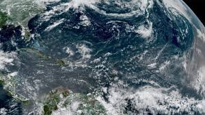
Understanding the Impact of El Niño on the 2026 Hurricane Season
As we approach the peak of the Atlantic hurricane season, meteorologists are keeping a close eye on a powerful climate driver: El Niño. Current projections suggest that the 2026 season might be one of the quietest we’ve seen in over a decade. But does a “below-average” forecast mean we can let our guard down?
According to the latest updates from the tropical meteorology project team at Colorado State University (CSU), the atmospheric conditions are shifting in a way that could significantly suppress storm development.
The Numbers: What the Experts Predict
The CSU forecast provides a sobering look at the expected activity for the Atlantic basin. Compared to a typical year, the numbers are notably lower:
- n
- Total Storms: Only 9 predicted (5 fewer than average).
- Hurricanes: Only 4 expected (3 fewer than average).
- Major Hurricanes (Category 3+): Just 1 forecast.
If these predictions hold true, 2026 would mark the fewest storms since 2014 and the fewest major hurricanes since 2013. This trend is echoed by other industry leaders, including Atmospheric G2 and The Weather Company, both of whom anticipate a less active cycle.
The Science: How El Niño Acts as a Shield
But why is El Niño causing this dip in activity? The answer lies in wind shear. Wind shear refers to the change in wind speed and direction at different altitudes in the atmosphere.
During a strong El Niño year, vertical wind shear over the Caribbean and the “main development region” (the area stretching from Africa to the Yucatan Peninsula) typically increases. This high wind shear essentially “rips apart” developing tropical depressions before they can organize into powerful hurricanes. Current data shows that wind shear in the Caribbean is already among the highest on record for early July.
The Danger of a “Quiet” Season
It is a common misconception that a below-average season equates to a zero-risk season. History has shown us that a single, poorly organized storm can still cause catastrophic damage.
Take Tropical Storm Arthur as a prime example. While it wasn’t a full-scale hurricane, it delivered record-breaking rainfall to Louisiana and created the wettest June day in New Orleans’ history. This serves as a critical reminder: you don’t need a Category 5 hurricane to experience devastating flash flooding.
Mixed Signals from the Ocean
While El Niño is the primary driver, ocean temperatures are providing a more complex puzzle. According to NOAA, sea surface temperatures are currently inconsistent:
- Cooler Zones: Waters from Western Africa to the Windward Islands are near or slightly below average.
- Warmer Zones: The region from the Azores to Bermuda and the Bahamas remains warmer than usual.
- The Gulf: Showing record warmth on the surface, but lower heat content beneath the waves.
Final Verdict: Stay Prepared
The combination of El Niño-induced wind shear and Saharan dust is likely to keep the Atlantic relatively quiet through August. However, the window for tropical activity remains open until November.
The bottom line: Regardless of the seasonal forecast, preparation is non-negotiable. If you live in a hurricane-prone area, ensure your emergency kit is ready and your evacuation plan is up to date. It only takes one landfall to turn a “quiet” season into a life-changing event.



