
Boston Weather Update: Brace for a Powerful Nor’easter
Happy Friday, Boston! While we’re currently dealing with a wintry mix, our attention is firmly focused on a significant nor’easter expected to impact the region Sunday night into Monday. This storm promises substantial snowfall, strong winds, and the potential for coastal flooding. Here’s a detailed breakdown of what you can expect.
Current Conditions & Weekend Outlook
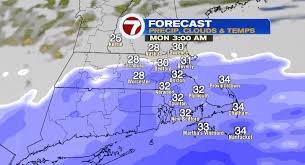
The current snow and sleet accumulation will largely subside by Saturday morning. However, scattered light snow showers are possible throughout Saturday, with highs in the low 30s and lows in the upper 20s. Sunday will be relatively quiet during the day, with cloudy skies, a chilly morning in the teens, and highs reaching the mid-30s.
The Nor’easter: Sunday Night – Monday
The main event begins late Sunday night and continues throughout most of Monday, extending into the early evening hours. Unlike the current mix, this storm is forecast to deliver entirely snow. This means both Monday morning and evening commutes will be significantly impacted by accumulating snowfall and hazardous road conditions. Expect challenging travel conditions on Tuesday morning, particularly on unplowed secondary roads.
Snowfall Totals
As a coastal storm, snowfall totals will vary depending on proximity to the storm’s center. Southeastern Massachusetts, Cape Cod, and the islands are predicted to receive the highest accumulations, with the potential for a foot or more of snow by Monday evening. Other areas will see less snowfall, but still substantial and plowable amounts.
Wind & Coastal Flooding
This storm isn’t just about snow; it’s also bringing strong winds. Inland areas can expect gusts of 30-40 mph on Monday, while the Cape and islands could experience gusts as high as 60 mph. These onshore winds raise concerns about coastal flooding. The National Weather Service in Boston has issued a Coastal Flood Watch for Monday and Tuesday morning’s high tides, anticipating minor to moderate flooding of 1 to 3 feet.
Key High Tide Times:
- Boston, Scituate, Sandwich: Around 3 a.m. Monday
- Barnstable, Chatham, Nantucket: Between 3 and 4 a.m. Monday
Looking Ahead
The storm is expected to wind down by Monday night. Tuesday will be dedicated to snow clean-up, with partly sunny skies and highs in the low 30s. Further wintry precipitation is possible from Wednesday through Friday, so stay tuned for updates.
For more detailed information and real-time updates, visit the WHDH 7News website and the National Weather Service.
Source: WHDH TV 7NEWS WLVI TV CW56, Sunbeam Television Corp


