
Stay Ahead of the Storms: Southwest Florida Weather Outlook
If you are currently in Southwest Florida, you know that the weather can change in a heartbeat. From oppressive heat to sudden torrential downpours, staying informed is not just about comfort—it is about safety. With activity ramping up across the region, keeping a close eye on a weather radar is your best defense against the elements.
Immediate Warning: Extreme Heat and Heavy Thunderstorms
The current atmospheric conditions are creating a volatile mix of high humidity and intense heat. Temperatures have already climbed into the low to mid-90s, with inland areas feeling the brunt of the heatwave. In hotspots like Ave Maria and Immokalee, “feels-like” temperatures are soaring between 106°F and 109°F.
As we progress through the afternoon and evening, expect the following:
- n
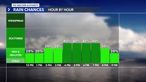
- Increased Storm Coverage: Thunderstorms will become more frequent, particularly along the I-75 corridor and surrounding Lake Okeechobee.
- Severe Weather Risks: Stronger cells may produce torrential rainfall, frequent lightning, and gusty winds.
- Flooding Potential: There is a low-end risk for localized flooding, especially in areas where storms stall or repeat their path.
Pro Tip: If you are heading out, keep your umbrella handy and monitor your local radar apps to avoid getting caught in a flash flood.
Looking Ahead: A Shift in the Pattern
While today looks chaotic, the forecast for the coming days shows a transition. Sunday will begin relatively quietly, though storm activity is expected to ramp up again by the afternoon, albeit with less overall coverage than today.
The real change arrives on Monday. A mass of drier air is slated to move into the region, which will naturally lower the chance of precipitation while allowing temperatures to climb even further.
The Saharan Dust Effect
By Tuesday, a fascinating meteorological phenomenon—Saharan dust—is expected to drift into Southwest Florida. This layer of dust, combined with the drier air, will act as a suppressant for rain, leading to a quieter middle and end of the week. We don’t expect scattered thunderstorms to return until the following weekend.
Boating Safety and Marine Conditions
For those hitting the water, the news is generally positive. No tropical development is expected over the next seven days. Winds will shift from the southeast to the south at 5–10 knots, with manageable wave heights of around 1–2 feet.
However, caution is key. Boaters are strongly advised to keep a radar active to track developing thunderstorms, which can materialize quickly during the afternoon and evening hours. For official marine alerts, always consult the National Oceanic and Atmospheric Administration (NOAA).
Stay cool, stay dry, and keep your radar on!



