
html
Urgent: Lake Effect Snow Warning Issued for Warren, McKean, and Elk Counties – Prepare Now!
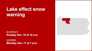
As winter’s grip tightens, residents across Warren, McKean, and Elk counties are bracing for a significant weather event. The National Weather Service (NWS) has issued a critical Lake Effect Snow Warning, effective from Sunday at 10:00 a.m. until Monday at 1:00 p.m. This isn’t just another snowfall; it’s a call to immediate preparedness and caution.
What to Expect: Heavy Snow and Blustery Winds
Forecasters are predicting intense conditions, with total snow accumulations ranging between a substantial 5 to 8 inches. But the snow isn’t the only concern. Powerful wind gusts, reaching up to an alarming 50 mph, are expected to accompany the snowfall. These strong winds will transform the fresh snow into a formidable challenge, leading to significant blowing and drifting that will make efforts to keep roads clear exceptionally difficult.
Navigating Hazardous Roads: A Major Concern
Travel during this period is strongly discouraged. The combination of heavy snow and high winds will rapidly create treacherous driving conditions. Here’s what commuters should anticipate:
- Slick and Hazardous Surfaces: Roads, and particularly bridges and overpasses, are highly susceptible to becoming icy and dangerous.
- Drastically Reduced Visibility: Visibilities could plummet to less than a quarter-mile due to intense falling and blowing snow, making driving extremely risky.
- Blowing and Drifting Snow: Expect snowdrifts to accumulate quickly, potentially obscuring road markings and creating unexpected hazards.
If travel is absolutely unavoidable, please exercise extreme caution and consider delaying your trip until the warning has passed. Always check local road conditions before departing.
Beyond the Roads: Potential Power Outages and Other Risks
The dangers of this lake effect snow warning extend beyond just travel disruptions. The sheer weight of the expected snow combined with the relentless strong winds poses a significant threat to infrastructure. Tree limbs, already weakened, could snap under the stress, potentially downing power lines and leading to sporadic but widespread power outages. Ensure your devices are charged and you have alternative light sources readily available.
Essential Preparedness: Your Winter Storm Kit
Being prepared is your best defense against the challenges of a winter storm. The NWS strongly advises having a comprehensive winter storm kit in your vehicle, especially if you must travel. Key items include:
- Tire chains and booster cables
- Flashlight with extra batteries
- Shovel
- Warm blankets and extra clothing
- Non-perishable food and water
- A well-stocked first-aid kit
- Any personal medications
These items could be life-saving if you become stranded.
Understanding Lake Effect Snow: A Unique Phenomenon
Lake effect snow is a unique meteorological phenomenon known for its localized and often intense nature. It occurs when cold air masses move across warmer lake waters, picking up moisture and then dropping it as snow on the downwind shores. What makes it particularly challenging is its variability: you can go from bands of heavy, blinding snow to relatively clear, dry weather within just a few miles. Visibilities and road conditions can change rapidly and without warning, emphasizing the need for constant vigilance.
Stay Informed, Stay Safe
This lake effect snow warning for Warren, McKean, and Elk counties is a serious advisory. Heed the warnings from local authorities and the National Weather Service. Prioritize your safety and the safety of those around you by staying home if possible, preparing for potential impacts, and being ready for rapid changes in weather. Stay tuned to local news and weather updates for the latest information.


