
Tropical Storm Bertha Makes Landfall: Tracking the Path Toward Texas
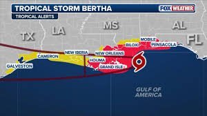
The 2026 Atlantic hurricane season has officially kicked off its land-impact phase. Tropical Storm Bertha has made its first landfall in St. Bernard Parish, Louisiana, bringing a cocktail of gusty winds, heavy rain squalls, and coastal flooding to the Gulf Coast. While Louisiana is currently in the crosshairs, residents are now shifting their attention to the west, questioning how this system will influence Houston weather and the wider upper Texas coast.
Louisiana’s Defense: Readiness and Impact
Governor Jeff Landry has emphasized that preparation is key, noting that even a minimal tropical storm can cause significant damage in low-lying communities. In New Orleans and surrounding parishes, the response has been aggressive:
- n
- Flood Mitigation: Over 30,000 sandbags distributed across Orleans Parish.
- Infrastructure: More than 90% of major drainage pumps are operational to combat potential inundation.
- Public Safety: Residents are encouraged to use resources like GetAGamePlan.org to prepare for current and future threats.
Will Bertha Affect Houston Weather?
As Bertha creeps westward at approximately 7 mph, the National Hurricane Center (NHC) has extended Tropical Storm Watches as far west as Sargent, Texas. For those monitoring Houston weather, the situation is evolving.
Meteorologists are watching a critical variable: tropical re-organization. While the storm is currently “ragged” due to vertical wind shear, there is a possibility that a secondary center of circulation could form over the warm waters of the Gulf. If this happens, Bertha could regain strength before reaching the upper Texas coast between Corpus Christi and Galveston by Thursday night.
What to expect in the Texas region:
- Wind Gusts: Potential for gusts up to 60 mph along the coastline.
- Flooding: Localized flash flooding and high surf.
- Rip Currents: Dangerous swimming conditions along the middle and upper Texas shoreline.
Widespread Destruction: From Florida to the Mid-Atlantic
While the center of the storm is in Louisiana, Bertha’s reach has been felt far and wide. In Florida, the impacts have been particularly heartbreaking for wildlife. The Alligator Point and Destin-Fort Walton Beach Sea Turtle Patrols reported that numerous nests were washed out by storm surges, potentially destroying hundreds of eggs.
Urban areas haven’t been spared either. In Panama City, Florida, winds were strong enough to topple a Waffle House sign, crushing several parked vehicles. Meanwhile, the storm’s moisture has interacted with cold fronts elsewhere, triggering a Flash Flood Emergency in West Virginia and severe weather outbreaks in New Jersey and the Carolinas, leaving thousands without power and disrupting over 10,000 flights nationwide.
The Science: Why Bertha Looks “Lopsided”
If you’ve seen the satellite imagery, you’ll notice Bertha doesn’t look like a classic spiral. According to experts at NOAA, this is due to northeasterly wind shear. This atmospheric force effectively rips the thunderstorm towers away from the low-pressure center, pushing the heaviest rain far to the south and west of the actual center of circulation.
Final Safety Reminder
Whether you are in the path of the storm in Louisiana or preparing for the impact on Houston weather, safety should be the priority. Always follow local evacuation orders, avoid driving through standing water (“Turn Around, Don’t Drown”), and keep a battery-powered radio handy for the latest NHC updates.



