
Super El Niño 2026: A Climate Wake-Up Call for Canada
Canada is currently facing a climatic phenomenon that defies historical norms. The Super El Niño 2026 is not just another weather cycle; it is a powerful atmospheric event that is intensifying faster than experts ever anticipated, leaving a trail of record-breaking temperatures and ecological challenges across the globe.
According to forecasts from Environment and Climate Change Canada (ECCC), 2026 is poised to be among the hottest years on record. This isn’t just a coincidence—it’s the result of a dangerous synergy between the natural El Niño cycle and the overarching effects of human-driven climate change.
What Exactly is a “Super El Niño”?
To understand the gravity of the situation, we must first distinguish between a standard El Niño and a “Super” event. While a typical El Niño is declared when ocean temperatures in the tropical Pacific rise 0.5 degrees Celsius above the long-term average, a Super El Niño occurs when those temperatures soar more than two degrees above the average.
The National Oceanic and Atmospheric Administration (NOAA) reports high confidence that this strong coupling of atmospheric and oceanic circulation will persist well into early 2027, with an 81% probability of a “very strong” event peaking between October and December.
The Immediate Impact: Wildfires and Heat Domes
The consequences of the Super El Niño 2026 are already visible across the Canadian landscape. From the boreal forests of the north to the prairies of the west, the effects are stark:
- n
- Record-Breaking Fires: Northern Ontario has seen unprecedented devastation, with over 7,250 square kilometres of forest torched—surpassing the previous records set in 2021.
- The Heat Dome Effect: High-pressure systems in the upper atmosphere have acted as “reservoirs,” trapping heat and humidity, leading to oppressive temperatures that linger long into the autumn.
- B.C. Crisis: British Columbia continues to battle dozens of out-of-control wildfires, complicating evacuation efforts and threatening local communities.
The Hurricane Paradox: Atlantic vs. Pacific
Interestingly, the Super El Niño 2026 creates a contrasting effect on hurricane seasons. Because of increased wind shear in the atmosphere—which effectively “tears apart” developing thunderstorms—the Atlantic hurricane season has remained unexpectedly quiet.
However, the opposite is true for the Pacific coast. Warmer sea surface temperatures provide more energy for tropical systems, leading to a highly active Pacific season with an increase in named storms and powerful cyclones.
What to Expect for the Canadian Winter?
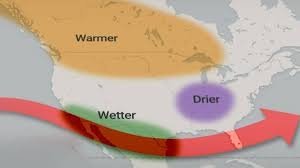
If you’re expecting a classic white Canadian winter, you might want to rethink your plans. Experts suggest that the upcoming season will be warmer and drier than usual. This shift brings a new set of risks:
- Reduced Snowpack: Less snow means less stored water for the spring, which could exacerbate droughts in Alberta and B.C.
- Increased Flooding: Warmer air holds more moisture. When it does rain, it tends to be more intense, leading to flash floods and freezing rain scenarios.
- The 2027 Wildfire Risk: A dry winter with minimal snowpack creates a “tinderbox” effect, potentially priming Canada for an even more severe wildfire season in 2027.
Closing Thoughts: Navigating an Uncertain Future
As noted by the European Union Copernicus Marine Service, global sea surface temperatures are hitting unprecedented peaks. While forecasts provide a roadmap, the sheer scale of the Super El Niño 2026 means we are entering uncharted territory.
Staying informed and adapting our infrastructure to handle these extremes is no longer optional—it is a necessity for the survival and resilience of Canadian communities.



