
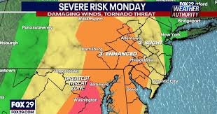
Storm Warning: Philadelphia Region Prepares for Intense Weather
Philadelphia and the surrounding Delaware Valley are facing a significant weather event this Monday, with forecasts predicting heavy rainfall, strong winds, and the potential for severe thunderstorms and even tornadoes. FOX 29 Meteorologists Kathy Orr and Scott Williams are providing the latest updates as the region braces for impact.
Current Warnings & Alerts
While a Tornado Watch that was in effect for the entire region until 7 p.m. has been lifted, residents in Kent County, Delaware, are urged to take immediate cover as a Tornado Warning remains in effect until 11 p.m. Monday. Additionally, a Severe Thunderstorm Warning is active for the Philadelphia area until 11:30 p.m. Monday.
The National Weather Service (NWS) has issued a Wind Advisory for portions of central, northern, and southern Delaware, southern New Jersey, and east central, northeast, and southeast Pennsylvania, lasting until 2:00 a.m. Tuesday. Winds are expected to reach 25 to 35 mph with gusts up to 50 mph.
What to Expect: A Timeline of the Storm
Rain began as scattered showers this morning and afternoon, but is now becoming widespread. The most intense period of the storm is expected around 5 p.m., with heavy bands of storms rolling across the Philadelphia area. Showers, accompanied by heavy downpours and pockets of strong thunderstorms, will continue throughout the evening.
The storm is anticipated to begin easing around midnight, though lingering moisture from a cold front could bring flurries.
The Greatest Threats: Wind & Potential Tornadoes
Forecasters emphasize that strong wind gusts pose the most significant threat associated with this storm. The NWS initially warned of potential wind gusts up to 80 MPH and isolated quarter-sized hail. Current reports indicate wind gusts reaching up to 60 mph.
Given the potential for severe thunderstorms to spawn tornadoes, the NWS urges anyone who spots a tornado to immediately seek shelter in a basement or a small, central room within a sturdy building. Review your family’s tornado safety plan now.
Impact & Rainfall Totals
Philadelphia and its suburbs are expected to receive between 1 and 1.5 inches of rain. This amount of rainfall is sufficient to cause localized flooding of low-lying creeks, streams, and other bodies of water. Be cautious when traveling and avoid areas prone to flooding.
Areas Under Severe Thunderstorm Warning
The Severe Thunderstorm Warning includes the following locations: Camden, West Chester, Norristown, Chester, Phoenixville, Lansdale, West Norriton, East Norriton, Yeadon, Westtown, Quakertown, Perkasie, Doylestown, Byram, Conshohocken, Hatboro, Souderton, Folcroft, and Bedminster.
Stay Informed & Stay Safe
Stay up-to-date on the latest forecast from the FOX 29 Weather Authority by downloading the free FOX LOCAL app. Remember to secure any outdoor items that could be blown away by the strong winds, and exercise extra caution while driving.
Resources:


