
Snow Squall Warning Issued for Kansas City Area
KANSAS CITY, MO (January 26, 2024) – A Snow Squall Warning is currently in effect for Johnson County, Kansas; Miami County, Kansas; Cass County, Missouri; and Jackson County, Missouri until 5:45 p.m. local time. Residents are urged to exercise extreme caution as quick bursts of snow and strong winds create hazardous travel conditions.
What is a Snow Squall?
Snow squalls are intense, short-lived snow showers accompanied by strong, gusty winds. These conditions can lead to a rapid decrease in visibility and the formation of slick, icy roads. The National Weather Service defines a snow squall as a sudden, localized heavy snow shower. Understanding this phenomenon is crucial for safe travel during winter months. You can learn more about snow squalls from the National Weather Service.
Impacts to Expect
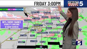
- Reduced Visibility: Briefly heavy snow showers combined with wind gusts up to 40 mph will significantly reduce visibility, making driving extremely dangerous.
- Icy Roads: Isolated slick spots are possible, particularly where the heaviest snow bands develop.
- Snow Accumulation: Expect a dusting to 0.5 inches of snowfall accumulation in short bursts.
- Plunging Temperatures: Following the snow squall, temperatures will drop dramatically, with lows in the 20s Fahrenheit expected this evening.
Safety Recommendations
If possible, delay your travel until snow chances decrease. If you must travel:
- Slow Down: Reduce your speed significantly.
- Pull Over: If visibility is severely reduced, pull over to a safe location and wait for conditions to improve.
- Be Prepared: Ensure your vehicle is equipped with a winter emergency kit, including blankets, a flashlight, and a phone charger.
Weekend Outlook: Bitter Cold Ahead
Saturday will bring bitterly cold temperatures, with morning lows in the teens and wind chills near 0 degrees Fahrenheit. Despite ample sunshine, wind chills will remain in the single digits throughout the day, with high temperatures only reaching around 20 degrees Fahrenheit. This is expected to be the coldest day of the year so far.
Sunday will offer a brief respite, with afternoon temperatures in the low 40s, but another cold front will arrive Sunday night, bringing another dramatic cool down into the work week.
Monday will see temperatures in the teens and mid-20s, with weaker winds and less hazardous wind chills. The remainder of the work week is expected to bring a return to milder temperatures, with afternoons in the 40s and plenty of sunshine.
Stay Informed
For the latest weather updates, download the KCTV5 Weather app. Stay safe and be prepared!
Copyright 2024 KCTV. All rights reserved.


