
Sleet Weather Alert: Brace for Hazardous Winter Conditions in Lapeer, Sanilac, and St. Clair Counties
A significant shift in our regional weather pattern is on the horizon, bringing with it a potent mix of snow, rain, and the dangerous potential for sleet weather and freezing rain. A comprehensive Winter Weather Advisory has been issued for Lapeer, Sanilac, and St. Clair counties, effective from 10:00 p.m. tonight until 4:00 p.m. Wednesday. Residents in these areas are advised to prepare for challenging conditions and exercise extreme caution.
Understanding the Weather Transition: What to Expect
This advisory highlights a complex weather system that will evolve significantly over the next 24 hours. Here’s a breakdown of what to anticipate:
- Tonight (Pre-3 AM): Expect predominantly snow across the affected counties, with significant accumulations of 4 to 6 inches possible, especially in areas least likely to see rain early on.
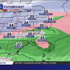
- Early Wednesday Morning (Post-3 AM): Temperatures will gradually warm, initiating a transition from snow to rain. This change will begin in southern regions and push northward by approximately 6:00 a.m.
- The Sleet and Freezing Rain Threat: During this crucial transition phase (roughly 3 a.m. to 6 a.m.), there’s a heightened possibility of sleet and freezing rain, particularly in areas just north of Metro Detroit. These conditions can create incredibly slick and hazardous surfaces, making travel extremely dangerous.
- Mid-Morning Wednesday (6 a.m. to 11 a.m.): Rain showers are expected to persist south of I-69, while areas further north will continue to experience snowfall.
- Wednesday Afternoon (Post-11 AM): A cold front will sweep through the region, quickly dropping temperatures and converting all precipitation back to snow. Snow showers are expected to taper off by late afternoon.
Snowfall totals will vary widely across the region due to this dynamic mix of precipitation, with the northernmost areas likely receiving the highest accumulations.
Beyond Wednesday: A Dip into Arctic Air
The colder temperatures aren’t just a fleeting visit. Much colder air is set to return by Thursday, bringing with it a few lake-effect flurries from Lake Michigan. The weekend forecast continues this trend, with several more chances for snow. Temperatures will remain significantly below average, with highs only reaching the mid to upper 20s by the end of the workweek, plummeting further into the teens and low 20s over the weekend. Expect wind chills to make it feel even colder, staying in the teens for most of Thursday.
Safety First: Navigating Hazardous Conditions
The potential for sleet weather and freezing rain means roads could become extremely icy and dangerous. Visibility may also be significantly reduced during periods of heavy snow or mixed precipitation.
Essential Tips for Preparedness:
- Monitor Local Advisories: Stay informed by continuously checking local weather alerts and forecasts.
- Travel Safely: If travel is unavoidable, allow extra time, reduce speed, and maintain a safe distance from other vehicles. Consider postponing non-essential trips. Check road conditions before you leave.
- Dress Appropriately: When heading outdoors, layer up with warm, waterproof clothing to protect against the cold and any precipitation.
- Prepare Your Home: Ensure your heating system is working efficiently. Have an emergency kit ready, including flashlights, extra batteries, and a first-aid kit.
For official, up-to-the-minute weather information and safety guidelines, always refer to authoritative sources such as Environment and Climate Change Canada or your local emergency management agency.
Stay vigilant, stay safe, and be prepared for this significant winter weather event impacting Lapeer, Sanilac, and St. Clair counties. Your safety is our top priority.


