
Unexpected Storms: Tornado Warning Triggers Alerts Across Massachusetts
Residents across several Massachusetts counties were put on high alert this Thursday as strong storms swept through the region, prompting the issuance of a tornado warning. The sudden shift in weather patterns created a tense atmosphere for those in the path of the storm.
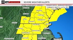
Which Areas Were Affected?
The tornado warning was specifically targeted at parts of the following counties:
- n
- Worcester
- Middlesex
- Hampshire
- Hampden
The warning was issued shortly before 5:30 p.m. and remained in effect until approximately 6:00 p.m. While the National Weather Service identified radar indicated rotation—a key sign that a tornado could form—no tornadoes were officially confirmed on the ground. Additionally, a severe thunderstorm warning extended until 7:00 p.m. for Worcester, Norfolk, and Middlesex counties.
Understanding the Risk: Tornado Watch vs. Warning
Earlier in the afternoon, a broader tornado watch was implemented. For those unfamiliar, a “watch” means conditions are favorable for severe weather, while a “warning” means the event is occurring or imminent.
The watch covered a wide swath of New England, including Essex, Middlesex, Worcester, Hampden, Hampshire, and Franklin counties in Massachusetts, as well as parts of New Hampshire and southern Maine. According to the Storm Prediction Center (SPC), risk levels were categorized as follows:
- 2% Tornado Risk: Areas north and west of Boston and the I-95 corridor.
- 5% Tornado Risk: A zone stretching from southwestern New Hampshire through Vermont and the Berkshires.
The Science Behind the Storm
While a 2% or 5% chance may seem negligible, meteorologists emphasize that these events are rare in southern New England. The primary driver for Thursday’s instability was a significant amount of vertical wind shear. This atmospheric condition allows storms to organize and potentially rotate, quickly escalating from a standard thunderstorm to a severe weather event.
More Than Just Tornadoes
Beyond the risk of rotation, the region faced several other hazardous conditions between 3 p.m. and 9 p.m., particularly north and west of Boston. Residents were warned to prepare for:
- Damaging straight-line winds that can knock down power lines.
- Frequent lightning strikes.
- Torrential downpours leading to localized flooding.
For real-time updates and safety protocols during severe weather, it is highly recommended to follow the National Weather Service and keep a battery-powered radio handy.


