
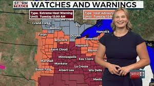
Severe Thunderstorm Watch: Volatile Weather Hits Northern Minnesota
Residents across Northern Minnesota are on high alert as weather patterns turn volatile. A severe thunderstorm watch has been issued, with meteorologists tracking powerful storm cells that could bring significant disruptions to the region. If you are in the affected area, now is the time to stay informed and prepare for potential hazards.
The Immediate Threat: What to Expect
These aren’t your typical summer showers. The current system moving through the region is capable of producing dangerous weather phenomena. According to recent tracking, these storms may bring:
- n
- Funnel Clouds: Increased risk of rotation and potential tornado development.
- Large Hail: Potential for significant property damage and hazardous driving conditions.
- Strong Winds: High-velocity gusts capable of downing tree limbs and power lines.
While clearing skies have appeared in some southern areas, cloud cover is rapidly filling back in, making it uncertain whether daytime mixing will dissipate the overcast skies or if warm air advection will keep the atmosphere primed for more activity.
Extreme Heat Warning: A Double Threat
As if the storms weren’t enough, a dangerous heat wave is settling in. Extreme Heat Warnings and Heat Advisories have been issued for east-central Minnesota and northwest Wisconsin. This combination of high humidity and soaring temperatures can be life-threatening if proper precautions aren’t taken.
To stay safe, we recommend following the National Weather Service (NWS) guidelines: stay hydrated, avoid outdoor activities during peak sun hours, and check on elderly neighbors.
Your Detailed Weekly Weather Outlook
Planning your week? Here is a breakdown of what to expect from Monday through Sunday:
- Monday: High near 74°F. Breezy with northeast winds (10-20 mph). 30% chance of rain during the day, increasing to 60% tonight with likely thunderstorms before 11 PM.
- Tuesday: Sunny and significantly warmer with a high near 86°F. Southwest winds with gusts up to 25 mph.
- Wednesday: Mostly sunny, high near 83°F. A 40% chance of showers and thunderstorms after 10 AM.
- Thursday: A beautiful day! Mostly sunny with a high near 84°F and light winds.
- Friday: Partly sunny, high near 76°F. Showers and thunderstorms are possible, mainly before 1 PM.
- Independence Day (Saturday): Partly sunny with a high near 75°F. Keep an umbrella handy, as there is a chance of showers and thunderstorms.
- Sunday: Partly sunny, high near 72°F. Continued chance of showers and thunderstorms to wrap up the week.
How to Stay Safe
When a severe thunderstorm watch is active, it means conditions are favorable for severe weather. To ensure your safety:
- Monitor Local Alerts: Keep your phone notifications on for emergency weather alerts.
- Have a Plan: Identify the safest room in your home (interior room, lowest floor).
- Track the Storm: Use an interactive radar to monitor the storm’s path in real-time.
Stay safe, stay cool, and keep an eye on the skies!



