
Minnesota Under Severe Thunderstorm Watch: What You Need to Know
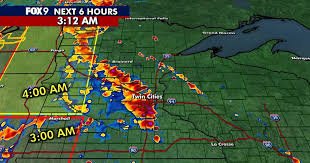
After a stiflingly hot and humid Tuesday, Minnesota is facing a volatile weather shift. A severe thunderstorm watch has been implemented across several regions, as a line of powerful storms tracks eastward from the Dakotas, bringing the threat of destructive weather to the Twin Cities and surrounding areas.
Meteorologists are closely monitoring the situation, warning residents to stay “sky aware” as the atmosphere remains primed for rapid storm development. From damaging straight-line winds to the possibility of isolated tornadoes, the overnight window has proven to be particularly unstable.
Key Weather Threats and Warnings
The National Weather Service (NWS) has issued multiple alerts across the state. While the intensity varies by location, the primary concerns include:
- n
- Extreme Wind Gusts: Some areas have already seen gusts exceeding 40 mph, with warnings in western Minnesota predicting gusts up to 80 mph.
- Significant Hail: Reports of pea-sized hail are common, but larger hail (up to 1.5 inches in diameter) is possible in high-risk zones.
- Tornado Potential: While isolated, the risk of quick spin-up tornadoes cannot be ruled out, particularly in far northwestern Minnesota.
- Heavy Rainfall: Localized flooding is a concern due to intense downpours occurring in short windows of time.
Regional Impact: From the Prairies to the Twin Cities
The storm system began its assault in western and central Minnesota, where a Level 2 slight risk and Level 3 enhanced risk were in effect. As the system pushed east, the Twin Cities metro area—including Minneapolis, St. Paul, and Bloomington—found itself under a severe thunderstorm watch until 7 a.m. Wednesday.
Counties such as Anoka, Chisago, Ramsey, and Washington have been under specific severe thunderstorm warnings, with potential wind gusts reaching 60 mph. The instability has not been limited to Minnesota, as the watch extends into western Wisconsin, affecting Polk and St. Croix counties.
Power Outages and Infrastructure Disruptions
The intensity of the wind has already left a mark on the state’s infrastructure. Early Wednesday morning, widespread power outages were reported. According to data from Xcel Energy, thousands of customers were left in the dark, with over 45,000 customers impacted in the early hours alone.
Residents are encouraged to check real-time outage maps and avoid downed power lines during the storm’s passage.
Looking Ahead: Is the Danger Over?
While some storms may weaken as they move into more stable environments, the weather remains precarious. Wednesday is expected to stay warm and humid, creating the perfect conditions for a second round of severe weather.
According to the NOAA guidelines, an enhanced risk (Level 3) remains for the Twin Cities metro, much of Wisconsin, and parts of Iowa and Illinois. Residents should prepare for another afternoon and evening of potential damaging winds and isolated tornadoes.
Stay safe, keep your devices charged, and continue monitoring local weather updates to ensure your family’s safety.



