
Severe Thunderstorm Warning: Urgent Weather Alerts for Missouri and Kansas City
Residents across the Midwest are on high alert as volatile weather patterns sweep through the region. The National Weather Service (NWS) has issued critical alerts, including a severe thunderstorm warning and specific tornado warnings, urging citizens to remain vigilant and seek shelter if necessary.
Urgent Tornado Warning for Missouri
In a critical development, a Tornado Warning was issued for Caldwell and Clinton Counties in Missouri. These high-intensity alerts indicate that dangerous conditions are imminent, requiring immediate action to ensure safety.
While some storms are appearing in a “hit-and-miss” fashion overnight, the instability of the atmosphere means that conditions can change in a matter of minutes.
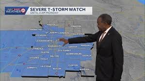
Expanding Severe Thunderstorm Watch
Beyond the immediate tornado threats, a broader severe thunderstorm watch is now in effect for the Kansas City metropolitan area and surrounding regions. This watch replaces previous alerts and covers a wide geographical stretch, including:
- n
- The entire Kansas City metro area.
- Regions stretching from north of St. Joseph.
- Areas extending south to Henry County.
- Eastern portions of Kansas.
According to the National Weather Service, the primary concerns for this overnight system are heavy rainfall and the high potential for localized flooding. However, residents should not overlook the possibility of gusty winds and small hail accompanying the stronger cells of the storm.
What This Means for Your Monday Morning
The unsettled weather pattern is expected to persist into early Monday morning. Because storms are developing in pockets rather than a single organized line, impact will vary by location. However, some areas may receive one inch or more of rain, significantly increasing the risk of flash flooding in low-lying areas.
Commuter Alert: If you are heading to work on Monday morning, be prepared for:
- Reduced visibility due to heavy rain.
- Slippery road conditions.
- Potential traffic delays caused by localized flooding.
When Will the Weather Improve?
There is a silver lining on the horizon. While stronger storms may shift east of the Kansas City metro later in the day, conditions are expected to stabilize by midday Monday. Drier air is forecasted to move in, ushering in cooler temperatures through the middle of the week.
Stay tuned to local weather broadcasts and the NWS for real-time updates to ensure your family’s safety during this severe weather event.


