
A Volatile Weather System Grips North America
After several days of intense meteorological activity, a powerful storm system is finally beginning to lose momentum. However, the aftermath has been devastating, fueling a multi-day severe thunderstorm outbreak that has left a trail of destruction across the central United States and continues to threaten regions stretching from the US-Mexico border all the way to the US-Canada border.
For those monitoring the National Weather Service (NWS) weather map, the pattern shows a system pushing south and east, shifting the risk of severe weather toward the eastern Great Lakes and northern New England.
Tornadoes and Destruction in the Heartland
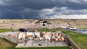
Since Saturday, the heartland has been the epicenter of this atmospheric chaos. Dozens of tornadoes have been reported, primarily concentrated in Nebraska, Iowa, Kansas, and Missouri. The most catastrophic event so far was an EF3 tornado that ripped through St. Libory, Nebraska, with peak winds reaching a terrifying 160 mph.
Key highlights of the tornado activity include:
- n
- Rare Emergencies: The NWS issued a rare tornado emergency in southeastern Nebraska after a touchdown in Pawnee County.
- Structural Damage: While some areas escaped major casualties, video evidence shows collapsed homes and destroyed buildings near Palmer, Nebraska.
- Near Misses: A stovepipe-shaped tornado cut through farmland in Richardson County, causing limited damage but highlighting the volatility of the system.
Beyond the Winds: Flash Floods and Hurricane-Force Gusts
The storm system didn’t just bring twisting winds; it delivered torrential rainfall that triggered flash floods across Indiana, Iowa, Kansas, and Nebraska. In Washington County, Indiana, emergency crews were forced to perform critical water rescues in Martinsburg and New Pekin.
Further north, the Great Lakes region felt the brunt of the system’s power. Destructive wind gusts—comparable to hurricane strength—were recorded at Chicago’s Midway Airport (79 mph) and near Grand Rapids, Michigan (81 mph), causing widespread disruption.
The Fire Threat: High Plains Under Siege
Ironically, while some regions drowned, others burned. The same weather system that brought rain to the east fueled rapidly spreading wildfires in the southern High Plains, driven by tinder-dry vegetation, low humidity, and extreme winds.
The situation remains critical in several areas:
- Texas Panhandle: The “Stinky Fire” in Potter County has scorched over 2,500 acres, threatening hundreds of structures. Meanwhile, the Hunggate and Chocolate Chip fires have burned more than 55,500 acres.
- Oklahoma & Colorado: The Sharpe Fire has crossed state lines, burning over 44,000 acres and triggering mandatory evacuations in Colorado.
- Kansas: Southwest Kansas has seen over 100,000 acres burn, with the Meade County Complex 1 remaining a significant concern for local authorities.
Looking Ahead: What to Expect on the Weather Map
As we move into Tuesday, the outlook shows slight improvement due to cooler temperatures and calmer winds. However, caution is still required. A Level 2 of 5 risk for severe thunderstorms remains in effect from Texas to the eastern Great Lakes.
Primary threats to watch for:
- Damaging winds and large hail through Tuesday evening.
- Potential for further flash flooding in the Lower Ohio Valley and central/eastern Texas.
- Elevated fire danger in New Mexico and eastern Arizona.
Stay tuned to local alerts and keep a close eye on the Environment Canada and NWS updates to ensure your safety during this volatile period.



