
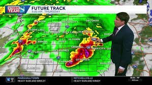
Stay Alert: Severe Storms Sweeping Through Iowa
Residents across Iowa, particularly those located south of I-80 and east of I-35, need to remain vigilant. A potent line of severe storms is currently pushing through the region, bringing a significant risk of dangerous weather conditions. According to the latest KWWL weather tracking, these storms are capable of producing large hail, damaging winds, and the potential for a few tornadoes.
If you are in the affected areas, now is the time to monitor local alerts and ensure your emergency kits are ready. Safety should be the priority as these systems move through the state.
The Storm Timeline: What to Expect
Understanding the timing of these weather events is crucial for planning your commute and keeping your family safe. Here is the projected timeline:
- n
- Tonight: Storms are expected to clear the area between 10 PM and 11 PM.
- Early Thursday (4 AM – 5 AM): A second, potent line of storms will surge into Iowa, potentially bringing destructive wind gusts ranging from 60 to 70 mph.
- Thursday Afternoon/Evening: After a brief lull, the atmosphere may recharge, leading to another round of severe weather. Areas east of I-35 and south of Marshalltown are at the highest risk for hail and tornadoes.
- Friday: The weather breaks! Expect a beautiful, sunny day with highs in the low 80s—perfect for catching up on outdoor chores.
- Saturday: Another system is forecasted to move through, bringing a return of strong storms. Keep a close eye on updates as the weekend approaches.
Looking Ahead: A Cooler Outlook
The good news is that once Saturday’s system clears out, a shift in wind direction will bring refreshing air from the north. Temperatures are expected to drop into the low to mid-70s with lower dew points, making the air feel significantly more comfortable. This dry and mild weather is expected to persist through the middle of next week.
How to Stay Informed
Weather patterns in the Midwest can change rapidly. To stay ahead of the storm, we recommend using high-authority resources for real-time tracking:
- n
- Monitor the National Weather Service (NWS) for official warnings and watches.
- Keep an eye on KWWL skycams for real-time aerial views of conditions across the state.
- Stay tuned to local emergency broadcasts for immediate evacuation or shelter orders.
Stay safe, stay informed, and keep an eye on the skies!



