
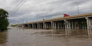
Extreme Rainfall Triggers Massive Flood Watch Across the Southern United States
A critical weather situation is unfolding across the Southern United States and Texas, leaving more than 60 million people vulnerable to the threat of devastating flash flooding. Following a holiday weekend saturated by relentless rain, a complex weather pattern known as an “atmospheric firehose” is funneling tropical moisture directly into the region, creating a high-risk environment for residents.
The Human Toll and Immediate Impact
The danger is not theoretical; it is already claiming lives and trapping citizens in perilous conditions. In Forest County, Mississippi, the tragedy struck when rushing floodwaters immobilized a vehicle at a low-lying crossing, resulting in one fatality. Similarly, first responders in Beeville, Texas, performed a harrowing rescue of a driver and an infant from fast-moving currents.
In North Carolina, specifically in Henderson County and Bat Cave, local fire departments have been overwhelmed by numerous calls regarding inundated roads and submerged properties, highlighting the volatility of the current climate.
Understanding the Current Risks: NOAA Alerts
The National Oceanic and Atmospheric Administration (NOAA) has issued several warnings to keep the public vigilant. Currently, a Level 2 out of 4 risk of flash flooding is in effect, covering a vast corridor from New Orleans to southern Virginia.
Key areas currently in the “bull’s-eye” of the storm include:
- n
- North and Central Texas: Specifically Dallas, Austin, and San Antonio.
- Coastal Texas & Louisiana: Houston, Corpus Christi, and Lake Charles are expected to face peak threats as the system shifts.
- Lower Mississippi Valley: Expected to experience repeated rounds of heavy thunderstorms through Friday.
The Paradox: Drought Relief vs. Flood Danger
While the current flood watch is alarming, there is a silver lining. Much of the South has been gripped by extreme drought conditions. This influx of moisture is providing essential relief to parched soils and reservoirs. However, because the ground is already saturated from previous precipitation, the land can no longer absorb water, significantly increasing the likelihood of immediate flash floods.
Safety Tips: How to Stay Safe During a Flood Watch
When a flood watch is in effect, preparation is key. According to Ready.gov, you should take the following precautions:
- n
- Avoid Low-Lying Areas: Never attempt to drive through flooded roads. Remember: Turn Around, Don’t Drown.
- Stay Informed: Keep a battery-powered radio or smartphone alerts active for real-time updates from local authorities.
- Prepare an Emergency Kit: Ensure you have clean water, non-perishable food, and essential medications.
- Move to Higher Ground: If you live in a flood-prone area, identify the safest route to high ground immediately.
This is a developing weather event. We urge all residents in the affected corridors to remain vigilant and prioritize safety over all else as the storm systems continue to stall over the Southern Plains.



