
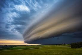
Red Warning: Severe Thunderstorms and Tornado Risks Hit Alberta
Residents and travellers across Alberta are being urged to stay vigilant as a volatile weather system moves through the province. With a red warning for severe thunderstorms now in effect, Environment and Climate Change Canada (ECCC) has issued alerts for high-risk conditions that could include destructive winds, massive hail, and the potential for tornadoes.
High-Risk Zones: What You Need to Know
The most critical weather activity is currently concentrated in central Alberta, extending into Saskatchewan. If you are in or traveling through the following areas, please exercise extreme caution:
- n
- Red Deer and Lloydminster: These areas are currently under the gun for severe activity.
- The QEII Highway: A large stretch of this major corridor is within the high-risk zone, making travel potentially dangerous.
In these high-risk zones, the weather threats are significant. Expect wind gusts reaching up to 110 km/h and thunderstorms capable of producing hail as large as six centimetres—roughly the size of a baseball. Furthermore, there is a persistent risk of tornado formation and heavy rainfall totaling up to 50 millimetres.
Special Alert for Calgary Stampede Visitors
For those heading to the city to enjoy the festivities of the Calgary Stampede, weather awareness is crucial this afternoon. While the event brings excitement, the overlapping storm system could bring sudden and severe disruptions. Stay tuned to local alerts to ensure your safety while attending the celebrations.
Moderate Risk: Edmonton and Calgary
While the highest risk is concentrated in the central corridor, major urban centres including Edmonton and Calgary are under a moderate weather risk. Residents in these cities should prepare for:
- n
- Wind Gusts: Up to 90 km/h.
- Hail: Possible hail up to four centimetres (golf ball size).
- Rainfall: Accumulations of approximately 30 millimetres.
Widespread Impact Across the Province
The instability isn’t limited to the central region. A broader risk of wind gusts up to 70 km/h, small hail (1 cm), and rainfall of up to 20 millimetres is affecting several other communities, including:
- n
- Grande Prairie & Fort McMurray
- Hinton & Edson
- High Level & Peace River
- Banff & Jasper
Stay Informed and Safe
Severe weather can change in an instant. We strongly recommend that all Albertans monitor official channels for real-time updates and emergency warnings.
For the most accurate and up-to-date weather watches and warnings, visit the official Environment and Climate Change Canada (ECCC) website.



