
Red Warning: Severe Thunderstorm Risk Hits Alberta and Saskatchewan
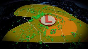
Residents and travellers across the Canadian Prairies are being urged to stay vigilant. A potentially turbulent weather pattern is settling over parts of Alberta and Saskatchewan, triggering a red warning for severe thunderstorms that could bring significant disruptions this Wednesday.
A powerful low-pressure system, combined with an amplified trough, is creating the perfect conditions for volatile weather. If you are in the affected regions, now is the time to secure outdoor furniture and plan your commutes with caution.
What are the Primary Threats?
This isn’t your average summer rain. The current weather system is expected to produce intense conditions that could lead to property damage and hazardous travel. The main risks include:
- n
- Massive Hail: There is a significant chance of large hail, with some stones potentially reaching the size of golf balls.
- Destructive Winds: Wind gusts are expected to exceed 100 km/h, with some areas along the Alberta-Saskatchewan border seeing peaks of up to 110 km/h.
- MCS Development: Meteorologists are monitoring the development of a Mesoscale Convective System (MCS), which can organize storms into a more potent and widespread line of severe weather.
Affected Areas: Who Should Be On Alert?
The most intense activity is forecast for central and northern Alberta, stretching into the Northwest Territories. Key locations under risk include:
- Edmonton
- Slave Lake
- Cold Lake
- Fort McMurray
- Hay River, N.W.T.
Additionally, the regions bordering Alberta and Saskatchewan are particularly vulnerable to the most severe wind gusts and largest hail stones.
A Tale of Two Regions: Southern Alberta’s Outlook
While the north and central regions brace for impact, residents in Southern Alberta can expect a different story. A drier weather pattern will dominate the southern region throughout the week. Looking ahead, temperatures are expected to climb back toward the 30°C mark by the weekend, offering a much calmer atmosphere compared to their northern neighbours.
How to Stay Safe
When a severe thunderstorm warning is in effect, safety should be your top priority. We recommend the following:
- Monitor local alerts via Environment Canada for real-time updates.
- Avoid unnecessary travel during the late afternoon and evening peak of the storms.
- Seek shelter in a sturdy building immediately if hail or high winds begin.
Stay tuned for more updates as the system evolves. Your safety depends on staying informed.



