Quebec Braces for Major Winter Storm: Heavy Snow, Rain, Gusty Winds Expected
A formidable winter storm system, originating from Ontario, is poised to sweep across Quebec mid-week, bringing a potent mix of heavy snowfall, significant rainfall, and powerful winds. While initial precipitation may serve as a precursor, the true impact of this system is expected to unfold from Tuesday night into Wednesday, intensifying conditions across various regions.
The Approaching System: What to Expect
This major low-pressure system is developing rapidly, and its full strength will be felt primarily from late Tuesday into Wednesday. A winter storm warning is already in effect for northern areas, signaling the severity of the impending weather. Residents are advised to prepare for challenging conditions, including:
- Heavy Snowfall: Particularly across northern and northeastern regions.
- Significant Rain: Predominantly in southern Quebec, with a late transition to snow.
- Strong Winds: Gusts exceeding 60 km/h in many snow-affected areas, leading to blizzard-like conditions and reduced visibility.
- Travel Disruptions: Hazardous road conditions are anticipated due to blowing snow and icy patches.
Regional Breakdown: Snow, Rain, and Mixed Conditions
The storm’s characteristics will vary significantly across Quebec, depending on temperature and trajectory. Here’s a detailed look at what different regions can expect:
Northeast Ontario & Northern Reaches
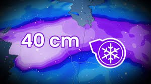
The heaviest snow accumulation is forecasted for northeastern Ontario, specifically around Kapuskasing and Timmins, where a staggering 35 to 40 cm of snow could fall by Thursday. Coupled with wind gusts often surpassing 60 km/h, whiteout conditions and severe blowing snow will make travel extremely difficult and dangerous. Winter storm warnings are active for these areas, urging utmost caution.
James Bay & Côte-Nord Regions
Further east, the corridor stretching from Abitibi to the Côte-Nord will also experience significant snowfall. Areas such as Matagami and Chibougamau, along with the northern parts of Saguenay, could see 20 to 25 cm of fresh snow. The system will reach the Côte-Nord approximately a day later, on Thursday, with Sept-Îles potentially receiving 15 to 20 cm of snow. Further south along the Côte-Nord, a mixed bag of precipitation is more likely.
Abitibi Region
Wednesday will begin with snowfall across Abitibi, with approximately 5 cm possible in the morning. However, a warmer air mass is expected to move in, causing precipitation to transition from snow to rain by Wednesday afternoon in areas like Val-d’Or and Rouyn-Noranda.
Southern Quebec
Southern Quebec will largely remain within the warm sector of the low-pressure system. Wednesday morning and afternoon will see intermittent, generally light rain. By Wednesday evening, the passage of a cold front will bring heavier rain and stronger winds. A gradual shift from rain to snow is expected Thursday morning as colder air advances, though significant accumulation is not anticipated for now. A secondary low-pressure system originating near James Bay could bring additional, albeit lighter, precipitation starting Thursday afternoon.
Navigating the Storm: Important Considerations
With Environment Canada weather alerts in effect, residents across affected regions should take necessary precautions. Reduced visibility from blowing snow and potentially slick roads from rain turning to snow will create hazardous driving conditions. It’s crucial to:
- Monitor local forecasts closely.
- Adjust travel plans or postpone non-essential trips.
- Check Quebec 511 for updated road conditions before heading out.
- Ensure emergency kits are stocked and vehicles are prepared for winter conditions.
Stay Prepared and Safe
This evolving Quebec snow storm demands attention and preparedness. Whether you’re facing heavy snowfall, persistent rain, or blustery winds, understanding your local forecast is key to staying safe. We extend our thanks to meteorologists Nicolas Lessard and Patrick Duplessis for their crucial contributions to this forecast.


