
Is a Brutal Winter Looming? The Polar Vortex and the Super El Niño Connection
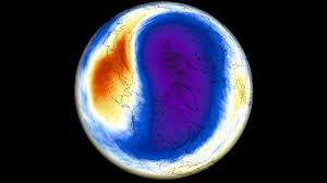
As we approach the 2026/2027 cold season, meteorologists are closely monitoring a powerful development over the North Pole. A new Polar Vortex is currently forming, characterized by rapid stratospheric cooling and a sharp drop in pressure. While the season is starting stronger than last year, the long-range signals suggest a dramatic shift is coming mid-winter.
The big question remains: will the current stability hold, or are we heading toward a major atmospheric collapse that could send Arctic air screaming south into the United States, Canada, and Europe?
What Exactly is the Polar Vortex?
To understand the risks, we first need to understand the mechanism. Think of the Polar Vortex as a massive, spinning wall of air that encircles the polar regions. It extends from the surface high into the stratosphere (over 30 miles up), acting as a containment barrier that keeps freezing polar air trapped in the Arctic.
This system operates in two primary layers:
- n
- The Stratosphere: The higher, more symmetrical layer where the vortex spins freely and strongly.
- The Troposphere: The lower layer, which is more “wobbly” and deformed by mountains and landmasses.
When the vortex is strong, the cold air stays put. However, when it weakens or “breaks,” cold “arms” of Arctic air leak out, triggering severe winter storms and record-breaking freezes in mid-latitude regions.
The 2026/2027 Forecast: A Tale of Two Halves
Current data shows a very healthy start. We are seeing a well-defined low-pressure core and a strong “donut-shaped” wind stream in the mid-stratosphere. Usually, this would suggest a milder winter for most of the Northern Hemisphere. But the seasonal trends tell a different story.
Forecasts for January and February 2027 indicate a significant deceleration. Model data from the ECMWF and UKMO suggest a power drop in the Polar Vortex, signaling a potential disruption that could lead to a chaotic mid-winter period.
The Wild Card: The Super El Niño
The primary driver behind this predicted instability is the development of a Super El Niño in the tropical Pacific. With ocean temperature anomalies exceeding 5 degrees above normal, this is one of the strongest events in decades.
How does El Niño affect the Arctic?
A strong El Niño alters planetary pressure waves. Specifically, it often creates a low-pressure zone in the North Pacific and high pressure over Greenland. This configuration pushes energy upward into the stratosphere, which can destabilize the Polar Vortex and trigger a catastrophic event known as Sudden Stratospheric Warming (SSW).
Understanding SSW: Split vs. Displacement
A Sudden Stratospheric Warming event occurs when temperatures in the stratosphere spike by dozens of degrees in just a few days. This disrupts the vortex in two main ways:
- The Split: The vortex breaks into two or more separate cores. This is often the most powerful type of event, leading to rapid and persistent cold outbreaks.
- The Displacement: The vortex is pushed off the pole toward a different region (like North America or Asia), causing localized extreme cold.
According to data from NOAA, the impact of a full vortex collapse is usually felt on the surface 10 to 30 days after the initial stratospheric event.
What This Means for Your Winter
If the current trends hold, the Super El Niño will likely act as the catalyst for a mid-winter Polar Vortex breakdown. For residents of the United States, Canada, and Europe, this could mean:
- n
- Increased Snowfall: More frequent and intense winter storms.
- Arctic Outbreaks: Sudden, severe drops in temperature that can plunge mid-latitudes into deep freezes.
- Unpredictable Weather: A disrupted jet stream leads to more extreme weather swings.
While it is too early to pinpoint the exact week of a collapse, the signals are clear: 2026/2027 has the potential to be a winter of extremes. We will continue to monitor the stratospheric winds and ocean temperatures to keep you updated on the upcoming cold season.



