Pittsburgh Weather Alert: Brace for a Week of Rain, Snow, and Chills
As November draws to a close and we look towards December 2025, Pittsburgh weather is gearing up for a dynamic and unpredictable week. From a midday sprinkle today to significant snowfall poised to impact your Tuesday morning commute, residents of Western Pennsylvania will need to stay vigilant and prepared. Here’s your detailed breakdown of what to expect in the coming days.
Today’s Outlook: Midday Rain and a Gradual Chill
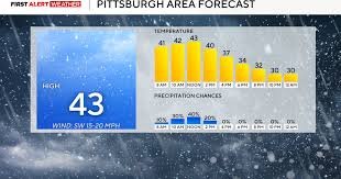
Today, November 30, 2025, the highest chance for rain showers is anticipated right around noon. If you’re out and about, be ready for a brief, but potentially impactful, downpour. Following this, temperatures are set to begin a steady decline throughout the afternoon. Our projected high for today is approximately 43 degrees Fahrenheit (6 degrees Celsius), but don’t expect this mildness to last.
For those attending the Steelers game, be sure to bundle up! Conditions at the stadium will feature temperatures dipping into the 30s Fahrenheit (around 0 to -1 degrees Celsius), accompanied by a brisk westerly wind that will make it feel even colder. Staying informed with up-to-the-minute forecasts is crucial for comfort and safety. For general weather information and safety tips, consider consulting reliable sources like The National Weather Service.
Beyond Today: A Week of Changing Skies for Pittsburgh
Monday is looking dry and relatively clear, offering a brief respite from the more active weather patterns. Enjoy the calm before the next system arrives.
First Alert Weather Day: Tuesday Snow Looms Over Pittsburgh
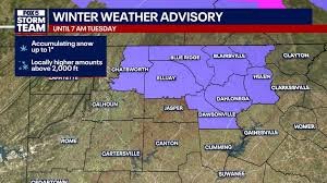
Tuesday has been designated a First Alert Weather Day due to the strong likelihood of morning snow. This winter weather event is expected to significantly impact the morning commute across the Pittsburgh area and surrounding regions. Initial forecasts suggest some accumulation will occur directly in Pittsburgh, likely just over an inch, but uncertainty regarding exact totals remains high. Commuters should plan for extra travel time and exercise extreme caution on the roads. For essential winter driving advice, visit resources like NHTSA’s Winter Driving Tips.
A primary concern for meteorologists over the past few days has been the precise positioning of the rain-to-snow line. Latest models indicate this line has once again dipped into West Virginia, meaning even areas south of I-70 should prepare for accumulating snow. If you’re located north of I-80, expect more substantial accumulation, with initial snow totals estimated between two and five inches before any additional lake effect snow contributes to the totals. It’s crucial to stay updated as these forecasts can shift rapidly.
Stay Prepared, Pittsburgh!
The latter half of the work week and stretching into the weekend is currently shaping up to be a mixed bag of winter weather, with several days bringing chances of both snow and rain. We will provide more precise details as those dates draw closer, so keep an eye out for updated forecasts.
- Stay Informed: Consistently check local weather updates and alerts from trusted sources.
- Plan Ahead: Adjust your travel plans, particularly for Tuesday morning, to avoid delays.
- Dress Appropriately: Layer up for the fluctuating temperatures and brisk winds to stay comfortable and warm.
Ensure you have access to real-time updates through mobile weather applications and local news channels to navigate the evolving Pittsburgh weather forecast effectively. Your safety and comfort are paramount!


