Orlando Weather Update: Heavy Rains and Flood Warnings Hit Central Florida
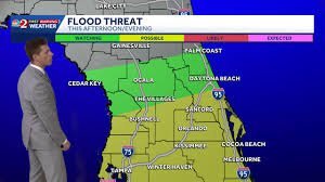
Central Florida Braces for Continued Wet Weather and Potential Flooding
If you have been glancing at the sky and wondering why it won’t stop raining, you aren’t alone. The current Orlando weather pattern is characterized by persistent moisture and frequent downpours that are continuing to impact Central Florida throughout the week.
A stalled frontal boundary has settled over the region, keeping rain chances elevated and creating a soggy environment for residents and visitors alike. While these showers are common, the intensity has increased, with heavy downpours and thunderstorms becoming more frequent, particularly during the afternoon hours.
The Influence of Hurricane Isaias
Many are asking if Hurricane Isaias is the cause of this instability. While the storm is churning in the Gulf of Mexico and is not expected to make a direct hit on Central Florida, its presence is certainly being felt. Isaias is pumping a significant amount of tropical moisture toward the east, which fuels the rain-heavy pattern we are experiencing.
According to the National Weather Service (NWS), the landfall is currently forecast for the northern Gulf Coast, but the outer bands and moisture plumes are keeping the region unsettled.
Flood Warnings and Localized Impact
The saturation of the ground has led to critical conditions in several areas. In Melbourne, heavy rainfall has already caused significant road flooding, leaving some motorists stranded. Consequently, a flood advisory has been issued for several counties, including:
- n
- Orange and Osceola
- Brevard and Volusia
- Seminole and Lake
- Marion and Putnam
- Flagler, St. Lucie, Martin, Indian River, Okeechobee, and St. Johns
Forecasters predict an additional 1 to 3 inches of rainfall through Saturday night, with some areas—particularly from Melbourne northward—potentially seeing over 3 inches. This increases the risk of localized flash flooding, so motorists are advised to exercise extreme caution.
When Will the Sun Return?
If you are waiting for a break in the clouds, there is a light at the end of the tunnel. Meteorologists expect drier air to move into the region by Monday, finally breaking the cycle of unsettled and soggy weather.
Until then, we recommend staying tuned to local weather alerts and monitoring real-time updates to ensure your safety during these heavy rain events.
📰 You May Also Like