
Tense Friday Night in Omaha: Severe Storm Alerts and Tornado Warnings
It was a night of high tension for residents of the Omaha metro area. After a grueling evening of atmospheric instability, the most urgent tornado warning and severe thunderstorm alerts were finally canceled at 11:15 p.m. Friday night. However, while the immediate danger subsided, the weather remained volatile, with lightning and heavy rainfall continuing to lash the region well past midnight.
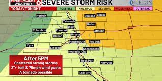
The Scope of the Storm: Which Areas Were Affected?
The storm system was extensive, triggering a series of warnings that shifted across the map as the cells evolved. The alerts covered a wide swath of Nebraska and western Iowa, keeping thousands of people on high alert. Specifically, the warnings impacted the following counties:
- n
- Nebraska: Washington, Saunders, Douglas, Dodge, and Burt.
- Iowa: Harrison, Monona, Shelby, Pottawattamie, Mills, Cass, Fremont, Montgomery, and Page.
For those unfamiliar with weather terminology, it is important to distinguish between a watch and a warning. A severe thunderstorm watch acts as a broad umbrella, signaling that conditions are favorable for storms to develop. A tornado warning, however, is a critical alert indicating that dangerous weather is occurring or imminent in a specific area.
The Science Behind the Storm: Heat and Humidity
Why was the atmosphere so volatile? Forecasters noted that temperatures in the Omaha metro climbed into the 90s on Friday, accompanied by a significant spike in humidity. This combination created the perfect “fuel” for fast-growing thunderstorms. While the potential for actual tornado rotation remained low, the primary threats were devastating hail, damaging winds, and torrential downpours.
To stay updated on real-time atmospheric conditions, it is always recommended to follow the National Weather Service (NWS) for official alerts and safety protocols.
Looking Ahead: Is the Danger Over?
Unfortunately, Friday night was only the beginning. Meteorologists warn that the pattern remains favorable for more instability. A new round of storms is expected to ignite in central Nebraska on Saturday afternoon, moving east toward the Omaha metro through the evening and overnight hours.
The key takeaway: While the immediate pressure of the Friday night warnings has eased, the weekend remains unpredictable. Residents are urged to keep their weather radios tuned and remain vigilant as the next wave of storms approaches.
Want to stay ahead of the storm? Subscribe to our newsletter to get the latest weather updates and breaking news delivered instantly to your inbox!


