
Urgent Weather Warning: Severe Storms Sweep Across North Texas
Spring has arrived in North Texas, but it is bringing more than just blooming flowers. This weekend, the weather pattern is shifting toward volatility, with a dangerous mix of unseasonably warm temperatures and the high potential for severe thunderstorms across the region.
The National Weather Service (NWS) has already sounded the alarm. A Tornado Watch is currently in effect for several counties, including Rains, Rockwall, Collin, Hunt, Hopkins, Lamar, Delta, Fannin, and Cooke. Residents in these areas should remain vigilant and be prepared to seek shelter immediately if warnings are issued.
Immediate Threats and Safety Alerts
The situation is critical in certain pockets of the region. A Severe Thunderstorm Warning has been issued for Delta, Hopkins, Hunt, and Lamar counties, with storms tracking southeast toward Sulfur Springs. Most urgently, a Tornado Warning was issued for Lamar County. If you are in the affected area, officials advise moving to a storm-resistant room or basement immediately.
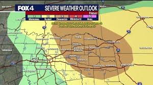
What to Expect: Friday’s Forecast
As we move into Friday, the weather will start with mostly cloudy skies. While the afternoon may see some clearing with high temperatures reaching the mid-to-upper 80s, the calm won’t last. Storm systems currently in Oklahoma are expected to track south, potentially bringing strong activity to the east and northeast of the Metroplex.
Primary risks for Friday evening include:
- n
- Damaging wind gusts
- Large hail
- Intense lightning strikes
Weekend Outlook: A Pattern of Instability
Meteorologists are keeping a close eye on the “dryline” to the west, which often acts as a trigger for severe weather in Texas. There is a 20% to 40% chance of severe storms each afternoon and evening throughout the weekend.
Saturday: A stronger atmospheric disturbance is expected to trigger storms in western areas late Saturday afternoon, eventually tracking east into the evening hours.
Sunday: A similar setup is anticipated, although storm coverage is expected to be slightly more scattered compared to Saturday.
Looking Ahead: Unseasonable Heat
The active weather pattern is likely to persist into next week. While the chance of storms will decrease by Monday and Tuesday, temperatures will remain unusually high for this time of year, with highs hovering in the high 80s and low 90s.
Stay tuned to local radar and official alerts to ensure you and your family remain safe during this turbulent spring season.


