
Prepare for a Wet Weekend: Flash Flood Warning Issued for North Texas
Residents across the Dallas Metroplex and surrounding North Texas areas need to keep their umbrellas close and their weather alerts on. A series of heavy rainfall events are expected to move through the region this weekend, bringing a significant risk of flash flooding before the summer heat returns in full force next week.
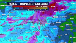
The Storm Forecast: What to Expect
According to the latest updates from the National Weather Service (NWS), the weather pattern will be volatile. Here is the breakdown of the expected conditions:
- n
- Friday: While afternoon showers may miss the heart of the Metroplex, widespread scattered storms are forecast for Friday night. These systems could bring erratic, gusty winds and frequent lightning.
- Saturday: This will be the peak of the precipitation. Expect multiple rounds of heavy rain with only temporary lulls, making it the highest-risk day for flooding.
- Sunday: The instability continues, with scattered heavy downpours lingering throughout the day.
Primary Threats and Safety Precautions
The primary concern for the region is the flash flood warning potential. When heavy rainfall occurs in a short window, urban areas and low-lying regions can flood rapidly. To stay safe, keep these tips in mind:
- n
- Avoid Floodwaters: Never drive through flooded roads. “Turn around, don’t drown” is the golden rule for flood safety. For more tips, visit Ready.gov.
- Boater Caution: Those on area lakes should exercise extreme caution due to sudden wind shifts and lightning.
- The 30-Minute Rule: Officials advise waiting at least 30 minutes after the final sound of thunder before resuming any outdoor activities.
Looking Ahead: From Rain to Triple-Digit Heat
The wet weather won’t last forever. Starting Monday, a strong high-pressure system will build over the region, effectively pushing the rain clouds away. However, this brings a new challenge: extreme heat.
Starting early next week, daily highs will consistently climb into the 90s. With humidity playing a role, heat index values are expected to approach triple digits, signaling the official return of summer-like conditions for North Texas.
Stay tuned to local weather updates to keep your family safe during this transition from torrential rain to scorching heat.


