NOAA Washington DC Winter Forecast: Is a ‘Super El Niño’ About to Hit?
NOAA Washington DC Winter Forecast: Preparing for a Potential ‘Super El Niño’
As the temperatures begin to drop, residents from the Mid-Atlantic to the West Coast are asking the same question: What does the winter forecast hold? For those keeping an eye on the NOAA Washington DC winter forecast and broader national trends, the answer might lie in a powerful climatic phenomenon: the Super El Niño.
Meteorologists are warning that we could be facing one of the most significant winter events in recent history. With a developing “Super El Niño,” the atmosphere is shifting in ways that could lead to a winter to remember.
What is a ‘Super El Niño’ and Why Does it Matter?
El Niño represents the “warm phase” of the Pacific Ocean’s cycle. Every few years, unusually warm water accumulates across the equatorial Pacific, weakening trade winds and shifting tropical rainfall eastward. This isn’t just a local ocean event; it acts as a global engine that alters weather patterns worldwide.
Current data suggests a staggering 83% chance that this current event will become one of the strongest on record. But how does this compare to the past?
Learning from History: 1997-98 vs. 2015-16
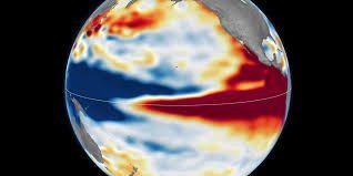
To predict the upcoming season, scientists are utilizing NASA satellite imagery to compare the current sea-level rises with previous “heavyweight” events:
- n
- The 1997–98 Event: One of the most powerful on record. Warm water surged all the way to the coast of South America, triggering global chaos, including heavy coastal flooding in the southern U.S. and severe droughts in Africa.
- The 2015–16 Event: Also exceptionally strong, but with a different fingerprint. The warm water didn’t reach South America as intensely, resulting in rainfall focused more on Central America and the southeastern U.S.
The Current Outlook: According to NASA, the current pattern closely resembles the 1997–98 event, suggesting a high potential for widespread and intense weather disruptions.
How This Affects the Washington DC and US Winter Forecast
When a Super El Niño takes hold, it nudges the jet stream, which acts as a highway for storms. This shift typically creates two distinct patterns across North America:
- Southern United States: Generally experiences wetter conditions, increased storm activity, and higher risks of flooding.
- Northern United States & Canada: Often sees warmer and drier winter weather than average.
For those tracking the NOAA Washington DC winter forecast, the Mid-Atlantic region often sits in a volatile transition zone. While a strong El Niño can bring milder temperatures, it also increases the potential for active storm tracks that can bring unexpected precipitation to the capital.
Final Thoughts: Stay Prepared
While scientists caution that the eventual impacts remain uncertain, the signs point toward an active and historic winter. Whether you are preparing for heavy rains in the south or a milder-than-usual winter in the north, staying informed via official meteorological channels is key.
Keep monitoring the latest updates from NOAA and NASA to stay ahead of the storm this season.
📰 You May Also Like