
Meteo Quebec: From Summer Heat to Unexpected Frost
Just when we thought summer had officially arrived in the province, spring is reminding us that it still holds the reins. After several days of delightful, summer-like warmth, a significant shift in the meteo Quebec is about to bring temperatures crashing down, with some regions facing a return to freezing conditions.
It has felt like a cinematic teaser; we were given a glimpse of the heat we’ve been waiting for all winter, only to be told the full feature film is delayed. On Tuesday, we saw the first 30°C peaks of the season, with Gatineau hitting a scorching 30.2°C. However, the weather is about to take a dramatic turn.
The Incoming Cold Air Mass
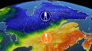
A massive cold air mass is descending upon southern Quebec. While the transition will feel gradual in some areas, the contrast will be jarring for others. To understand the strength of this system, one only needs to look at the forecasts for northern regions, which will feel the impact first.
Wednesday’s Forecast: A Tale of Two Regions
Wednesday will showcase a striking temperature divide across the province:
- n
- Montreal: Expected maximums of over 25°C, with a humidex making it feel closer to 30°C.
- Val-d’Or: A stark contrast, with a maximum of only 5°C—temperatures more typical of mid-April.
- Chibougamau: Even colder, with a maximum of 4°C and a wind chill that could make it feel like -1°C.
Frost Warnings and Gardening Alerts
The most critical part of this meteo Quebec update is the frost warning during the growing season. For residents in Abitibi-Témiscamingue and Saguenay-Lac-Saint-Jean, the night between Wednesday and Thursday could be hazardous for sensitive plants.
Expected minimums for Thursday morning include:
- Chibougamau: -3°C
- Val-d’Or: -2°C
- Saguenay: 0°C
Expert Tip: If you have recently planted your garden or have frost-sensitive greenery, it is highly recommended to cover your plants by Wednesday evening to prevent damage.
Impact on Southern Quebec
While the south won’t see freezing temperatures, the “temperature shock” will be significant. After hitting 30°C on Tuesday, the mercury will dive sharply by Thursday morning. Forecasted lows include:
- Gatineau: 5°C
- Quebec City: 3°C
- Mont-Laurier: 1°C
- Sept-Îles: 4°C (continuing its trend of missing out on the recent heatwave).
For real-time updates and official weather alerts, we recommend monitoring Environment Canada to stay prepared for any sudden changes in the forecast.
Stay warm, keep your plants covered, and keep an eye on the sky!



