
Brace Yourselves: A Powerful Spring Snowstorm is Hitting the Prairies
Residents across the Prairies are being urged to prepare for a significant weather event. A powerful, slow-moving low-pressure system is currently tracking toward the region, bringing a heavy dose of winter just as spring should be settling in. This Saskatchewan snow storm is expected to bring hazardous conditions, with some areas facing massive accumulations and dangerous visibility.
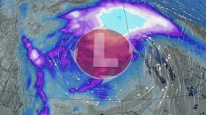
What to Expect: Snow Totals and Timing
The storm is set to intensify and move into southern Manitoba by Thursday, before retrograding westward into Saskatchewan on Friday. This unusual movement means the system will linger, dumping significant amounts of snow over several days.
- Northern and Rural Areas: Expect the heaviest hits, with accumulations ranging from 30 to 50+ cm.
- Southern Saskatchewan: Cities including Prince Albert, Saskatoon, and Moose Jaw could see between 10 and 25 cm of snow.
- Regina: Forecasts suggest a mix of rain and wet snow.
Hazardous Conditions and Travel Warnings
This isn’t just about the snow volume; the accompanying conditions are what make this storm particularly dangerous. A sharp temperature drop of nearly 20°C is expected across southern Alberta and Saskatchewan early Thursday.
With wind gusts reaching between 60 and 90 km/h, the risk of whiteout conditions is extremely high. Blowing snow will severely reduce visibility, making driving perilous. Authorities are issuing specific warnings for those traveling on:
- The Yellowhead Highway
- Highway 1 (west of Saskatoon and Regina)
We strongly recommend checking Saskatchewan Road Reports before attempting any long-distance travel during this period.
The Silver Lining: Moisture for the Fire Season
While the immediate impact of the storm is disruptive and hazardous, there is a long-term benefit. This prolonged precipitation will provide much-needed moisture to the soil, which is critical as the region prepares for the upcoming wildfire season.
Stay Safe and Informed
As the system dissipates over the weekend, residents should remain vigilant. Snowsqualls—narrow but intense bands of heavy snow—may develop near Edmonton, Cold Lake, and Prince Albert, causing sudden drops in visibility and quick accumulations of 5–15 cm.
For the most accurate and real-time updates, keep a close eye on Environment Canada to ensure you are prepared for any sudden changes in the forecast.


