
Unpredictable Shifts: What to Expect from the Current Las Vegas Weather
If you’ve noticed the skies shifting over the Silver State, you aren’t alone. The Las Vegas weather and the broader Nevada region are currently experiencing a complex dance of atmospheric pressures, bringing an unexpected mix of rain, wind, and temperature swings.
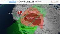
Currently, a low-pressure system is sweeping through the region. While much of the heavy precipitation has remained east of Reno, areas along and east of U.S. 95 have already felt the impact of early showers. Meteorologists describe the movement of these storms as a “pinwheel” or “Ferris wheel” effect, where showers rotate counterclockwise around the low-pressure center.
The Impact of Hurricane Polo Remnants
The most significant driver of this volatility is the remnants of Hurricane Polo. As these remnants push into the desert Southwest, they are interacting with local low-pressure systems to create a volatile environment. While Nevada sees varying amounts of rainfall—with some pockets receiving up to an inch of rain—the real intensity is shifting toward the southeast.
Residents in Arizona and New Mexico should remain vigilant, as the combination of the remnants and the departing low-pressure system is expected to trigger very heavy rainfall and potential flooding in those areas. For more detailed regional warnings, you can check the National Weather Service.
What’s Next for Nevada?
Fortunately, the instability is temporary. Here is the breakdown of the upcoming forecast:
- n
- Monday Night: Skies are expected to clear as the low-pressure system exits Nevada.
- Tuesday: A beautiful, clear day is forecasted for the Las Vegas valley.
- Wednesday Onward: High pressure will take hold, leading to a drier-than-average trend.
A Warm Welcome to October
Don’t put away your summer clothes just yet. The forecast indicates a hot start to October, with high temperatures consistently reaching well into the 80s. This is a classic example of the autumn transition in the Southwest, where the atmosphere fluctuates between warm spikes and the first whispers of winter chill.
To stay informed about long-term climate patterns and oceanic influences like those from the NOAA, it is always wise to keep an eye on satellite imagery and official meteorological updates.
Pro Tip: Whether you are a local or visiting the Strip, always carry a light jacket during this transition season—the desert is famous for its rapid temperature drops once the sun sets!



