
KCTV5 Weather Alert: Tornadoes and Severe Storms Hit Kansas City Metro
Residents across the Kansas City metropolitan area are on high alert as the National Weather Service has confirmed a tornado touchdown in Clay County, MO. With severe weather systems moving through the region, staying informed via KCTV5 weather updates is critical for your safety and the safety of your family.
Immediate Threats: Tornado and Severe Thunderstorm Warnings
Urgent warnings are currently in effect for several counties. If you are in the following areas, please seek shelter immediately:
- n
- Tornado Warnings: In effect for Clay, Jackson, and Ray counties (until 9:30 p.m.), as well as Platte and Wyandotte counties.
- Destructive Severe Thunderstorm Warning: Active for Jackson, Cass, Johnson, and Miami counties until 9 p.m. Be prepared for devastating winds reaching up to 80 mph.
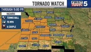
The intensity of the system was highlighted by reports from KCI, where wind gusts of 79 mph were recorded. A broader Tornado Watch remains in place until 11:00 p.m. tonight, meaning conditions are favorable for damaging winds, large hail, and additional tornadoes.
What to Expect Tonight
Saturday has been designated as a First Warn Weather Day—the highest alert level for impactful weather. While some models suggest a “broken line” or “cluster” of storms (meaning not every neighborhood will be hit), the peak window for severe impacts in the metro area is expected between 8 p.m. and 11 p.m.
Additionally, a Flood Watch is active for the metro and areas to the south, lasting through tomorrow morning. We urge everyone to follow safety guidelines provided by Ready.gov to ensure you are prepared for flash flooding and wind damage.
The Forecast: Sunday and the Upcoming Workweek
After a tumultuous Saturday, there is a light at the end of the tunnel. Here is what the KCTV5 weather forecast looks like for the coming days:
Sunday: A Refreshing Change
Sunday will bring a completely different atmosphere. A cold front will push through, resulting in significantly cooler temperatures and lower humidity. Expect a high of around 73°F with partly cloudy skies and dry conditions—perfect for a relaxing day outdoors.
The Workweek Outlook
- n
- Monday: Remaining dry and pleasant.
- Tuesday: A slight increase in activity with a 30% chance of isolated, non-severe showers as temperatures climb back into the 80s.
- Wednesday: Caution is advised. Heat and humidity will surge back, fueling a 50% chance of severe storms. This will be another First Warn day, with non-storm wind gusts potentially reaching 40 mph.
Stay tuned to KCTV5 for real-time updates and the most accurate weather tracking in the region.



