
Iowa Weather Alert: Severe Thunderstorms and High Winds Grip Central Iowa
Residents across central and southwest Iowa are on high alert as a Severe Thunderstorm Watch remains in effect. With volatile atmospheric conditions, the region is bracing for impactful weather that could disrupt morning commutes and cause property damage.
Immediate Threats: What to Expect This Morning
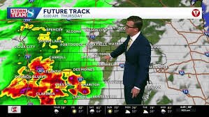
As of 5 a.m., powerful storm cells have been pushing into southwest Iowa. These systems are not just bringing rain; they carry a significant risk of severe weather, particularly south of I-80. Key threats include:
- n
- Damaging Winds: Some storm cells are capable of producing wind gusts of 70 mph or greater, which can easily knock down trees and power lines.
- Large Hail: Hailstones may grow to 2 inches or larger, posing a risk to vehicles and agriculture.
- Flash Flooding: Heavy rainfall is accompanying these storms. This is especially critical for southern Iowa, where saturated ground from previous rains increases the likelihood of flooding.
While the threat of tornadoes remains very low, meteorologists warn that it cannot be entirely ruled out if internal surges or twists develop within the storm line. For real-time tracking, residents are encouraged to monitor the National Weather Service for official warnings.
The Road Ahead: Afternoon Outlook and Weekend Forecast
The morning round of storms will push out late today, but the atmosphere remains unstable. Here is what you can expect for the rest of the week:
Today and Tonight
Expect scattered showers and storms to persist into the afternoon. The eastern and southeast portions of Iowa may see a second round of severe activity as a cold front pushes eastward. The intensity of these afternoon storms depends on how quickly the atmosphere recovers from the morning’s activity.
- High: 78°F
- Tonight: Clearing skies with a low of 57°F.
Friday: The Perfect Summer Day
Good news for those with outdoor plans! Friday is shaping up to be a beautiful break from the volatility. Expect sunshine, lower humidity, and pleasant temperatures.
- High: Around 82°F
- Conditions: Dry, warm, and a mild southwest breeze.
Saturday and Sunday: The Return of the Rain
Enjoy the break while it lasts. Humidity returns on Saturday, bringing a fresh round of storm chances, particularly across southern Iowa. These could impact afternoon and evening plans for those in central Iowa as well. By Sunday, the region will cool down and dry out, with highs returning to the comfortable 70s.
Stay Informed and Safe
Weather conditions in the Midwest can change in an instant. To stay ahead of the storm, keep an eye on local radar and live skycams to monitor cloud cover and precipitation in your specific area. Always have a weather radio or a reliable alert app ready during severe thunderstorm watches.


