
Severe Storms on the Horizon: What You Need to Know About the KCCI Weather Outlook
Weather patterns are shifting rapidly across the Midwest, and those following the KCCI weather updates should prepare for a volatile few days. From merging storm lines to sudden temperature drops, the region is in for a ride. Whether you are in Des Moines, Ames, or the surrounding rural corridors, staying informed is your best defense.
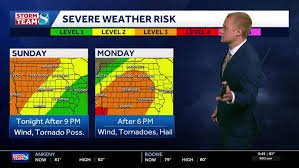
Tonight’s Forecast: Storm Lines Heading East
The immediate concern begins with storms currently igniting over eastern Nebraska and South Dakota. As evening approaches, these individual cells are expected to merge into a single, potent line of storms moving into western Iowa around sunset.
- n
- 9:00 PM: The storm line is projected to hit the Hwy 71 corridor, affecting areas such as Carroll and Audubon. The primary threat here will be damaging wind gusts, though a few isolated tornadoes remain a possibility.
- 11:00 PM to Midnight: The system will progress toward Des Moines, Ames, and the I-35 corridor. While the overall severe threat will be decreasing by this time, strong winds may still persist.
- After Midnight: Expect a transition to mostly non-severe thunderstorms and showers lasting until Monday morning.
n
n
n
Monday: A Brief Calm Before the Next Wave
Monday morning will bring some relief as rain clears, leading to a drier start to the day. Expect partly to mostly cloudy skies with southerly winds and highs reaching the 70s to low 80s.
However, the peace won’t last. By Monday afternoon, new storms will ignite in northeast Kansas and push northeast along a boundary. This front will stretch from Council Bluffs through Fort Dodge and up to Mason City.
Looking Ahead: A Noticeable Cool-Down
If you’ve been enjoying the warmth, it’s time to grab a light jacket. By Tuesday morning, rain will exit Iowa, leaving behind clouds and northwest winds gusting up to 30 mph.
The most significant change will be the temperature. Humidity will drop, and highs will plummet into the 60s, a trend expected to continue through Wednesday and Thursday.
How to Stay Safe and Updated
To ensure you have the most accurate, real-time data, we recommend monitoring official channels. You can track live conditions via The National Weather Service (NWS) or by checking local skycams for aerial views of storm progression across the state.
Quick Summary Forecast
| Period | Expected Conditions | High/Low |
|---|---|---|
| Today | Windy, partly cloudy, morning showers | High 82°F |
| Tonight | Evening storms (mostly West) | Low 64°F |
| Tomorrow | Severe PM storms possible | High 82°F |
| Tuesday+ | Cooler, breezy, clearing skies | High 60s |


