
Kansas Tornadoes: Staying Safe During Severe Weather
Kansas residents have recently experienced severe weather, including tornado watches and warnings. While the immediate tornado threat has subsided, the risk of severe storms remains elevated throughout the week. This article provides the latest updates, forecasts, and essential safety tips to help you stay prepared.
Recent Events & Current Warnings
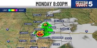
The recent Tornado Watch has ended, with storms expected to move out of eastern Kansas counties around midnight. While the tornado threat is now low, strong winds and hail remain potential hazards. Flood Warnings are currently in effect for several counties:
- Douglas & Franklin Counties: Flood Warning until 12:30 AM Tuesday
- Cass, Johnson, & Miami Counties: Flood Warning until 4:00 AM Tuesday
Tonight, expect partly cloudy skies and breezy conditions. Low temperatures will hover around 68 degrees, potentially tying a record for the warmest low temperature set in 2006.
Tuesday’s Severe Weather Outlook
While Tuesday begins warm and dry, clouds will increase throughout the afternoon, bringing with them a rising chance of storms. The Storm Prediction Center has issued a 2/5 severe risk for Tuesday afternoon and evening (between 6 PM and midnight). Although storm development isn’t certain, any storms that form could bring hail, severe winds, and the possibility of brief tornadoes.
Key Forecast for Tuesday:
- 60% chance of rain and severe storms, primarily late in the day through the night.
- Partly cloudy skies with highs in the upper 80s.
- Southwest winds gusting up to 30 mph.
Stay updated with the latest weather information by downloading the KCTV5 Weather app.
Looking Ahead: Wednesday & Beyond
A second round of severe storms is possible on Wednesday, contingent on Tuesday’s storms clearing out. The setup is similar, with a 2/5 severe risk and potential for strong to severe storms late in the day and into the night. Hail and wind are expected to be the primary threats. Spotty to scattered rain and storms are also possible in the morning, which could influence the severity of storms later in the day.
Wednesday Forecast:
- 60% chance of rain and storms.
- Temperatures slightly cooler, in the upper 70s.
- Continued breezy conditions.
Thursday offers a respite from the severe weather, with dry, sunny, and warm conditions. Temperatures will climb back into the mid-80s.
Further Storm Chances
Storm chances return on Friday, with a potential line of storms late in the day and into the night. A level 2/5 risk for severe storms is in place, with wind and hail as the primary concerns. Before the storms arrive, expect another warm day with highs in the low 80s and gusty south winds up to 35 mph.
Friday Forecast:
- 70% chance of storms, most likely after sunset.
- Breezy conditions.
The weekend looks more settled, with lingering rain possible Saturday morning (40% chance) clearing out quickly. Expect much cooler temperatures, with highs in the upper 50s on Saturday and mid-60s on Sunday, accompanied by breezy northwest winds.
Source: KCTV5 News


