
Will a Tropical System Crash the Party? July 4th Atlantic Weather Outlook
As millions of Americans prepare for Independence Day celebrations, the eyes of meteorologists are turning toward the Atlantic. While the ocean has been relatively quiet so far this season, the July 4th Atlantic weather forecast is showing signs of potential tropical development that could impact the Southeastern coast.
Whether you are planning a beach getaway or a backyard barbecue, staying informed about the latest tropical activity is crucial for a safe and stress-free holiday weekend.
The Current State of the Atlantic
So far, the Atlantic hurricane season has been unusually subdued. The only named system to emerge was Tropical Storm Arthur, which remained disorganized and short-lived over the Gulf. However, the atmosphere is shifting, and the National Hurricane Center (NHC) and other monitoring agencies are keeping a close watch on the waters off the Southeastern US.
The Red Flags: What Could Trigger a Storm?
Meteorologists have identified a few key factors that could lead to tropical organization mid-to-late next week:
- Low-Pressure Zones: A drawn-out area of low pressure, fueled by leftover energy from a previous frontal zone, is expected to settle over the Southeast.
- Extreme Sea Surface Temperatures: The subtropical Atlantic waters east of Florida are currently exceptionally warm—well above the seasonal average—providing the “fuel” necessary for storm intensification.
- Favorable Wind Patterns: Hostile upper-level winds, which usually rip developing storms apart, have weakened recently, opening a window for potential growth.
The Silver Lining: Why a Major Storm is Still Unlikely
Despite the warm waters, there are several “defense mechanisms” in the atmosphere that may prevent a full-blown tropical system from forming:
- Abundant Dry Air: Significant pockets of dry air are surrounding the front zone, which typically inhibits the moisture needed for thunderstorm development.
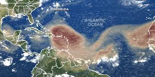
- Saharan Dust: A thick blanket of Saharan dust is continuing to drift across the Atlantic. This dust dries out the atmosphere and suppresses tropical activity across the Main Development Region.
- Returning Wind Shear: Forecast models suggest that strong upper-atmosphere winds will return in July, potentially disrupting any waves attempting to organize between Africa and the Caribbean.
What Happens if a System Forms?
If a tropical system does manage to organize despite the dry air and dust, its path will likely be influenced by a massive heat dome currently baking the Eastern United States. This high-pressure system could act as a steering mechanism, potentially directing any developing activity back toward the U.S. mainland.
Final Verdict for Your July 4th Plans
For now, there is no need for alarm, but there is a reason for vigilance. While the odds of a major disruption remain low, the combination of warm waters and specific atmospheric conditions means we cannot rule out tropical development.
Pro Tip: Keep an eye on local weather updates and official reports as we approach the holiday weekend to ensure your celebrations go off without a hitch.


