
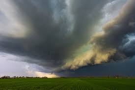
URGENT ALERT: Over 130,000 residents across Illinois were recently advised to move indoors as potent severe thunderstorms swept through the region. The National Weather Service (NWS) issued immediate severe thunderstorm warnings, underscoring the swift and sudden nature of fall weather threats.
While spring is traditionally known for intense storms, Illinois experiences a “secondary severe weather season” in the fall, explained NWS meteorologist Ben Deubelbeiss to Newsweek. Though less frequent, these autumnal storms demand the same urgent attention and preparedness.
Immediate Warnings Signal High Alert
The immediacy of these warnings highlights the critical need for rapid action. Unlike some weather advisories that can be issued hours or days in advance, these severe storm warnings were triggered mere minutes after meteorologists detected hazardous weather systems forming and moving across parts of the NWS Lincoln forecast area. This rapid issuance signifies that conditions were escalating quickly, posing an immediate threat to life and property.
The NWS office in Lincoln, Illinois, specifically issued two distinct severe thunderstorm warnings earlier today, urging prompt safety measures from residents in affected zones.
First Warning: Decatur Region Faces Hail Threat
The initial warning, issued at 1:20 p.m. Central time, covered northern Moultrie County, southern Piatt County, southwestern Champaign County, northwestern Douglas County, and southeastern Macon County. This warning was active until 2 p.m. Central time.
At the time of issuance, a significant severe thunderstorm was positioned over Decatur, tracking eastward at a rapid 45 mph. Forecasters specifically warned of quarter-sized hail, a threat capable of inflicting substantial damage to vehicles and other outdoor property.
Second Warning: Eastern Illinois Braces for Larger Hail
Just three minutes later, at 1:23 p.m. Central time, a second NWS severe thunderstorm warning was put into effect. This alert was issued as another dangerous storm was located near Hidalgo, or close to Greenup, also moving east at 45 mph. This broader warning encompassed northwestern Crawford, northeastern Jasper, Clark, and southeastern Cumberland counties.
This particular storm carried an even greater risk, with meteorologists forecasting hail up to a half-dollar size. Hail of this magnitude is officially classified as severe and carries the potential for significant damage to buildings and vehicles, as well as posing a direct injury risk to people and animals caught outdoors.
The NWS warning specifically highlighted that this severe thunderstorm was expected to remain over primarily rural areas, including locations like Hazel Dell, Lincoln Trail State Park, Darwin, Rose Hill, West Union, and Yale. Additionally, it impacted stretches of Interstate 70 between mile markers 117 and 129, and again between mile markers 147 and 154, prompting extra caution for travelers.
Prioritize Safety: Move to an Interior Room
The consistent message from the NWS Lincoln during these severe thunderstorm warnings is clear: “For your protection move to an interior room on the lowest floor of a building.” This fundamental safety advice is crucial during any severe weather event, providing the best protection against high winds, lightning, and hail. While the immediate warnings might expire, residents throughout Illinois are continuously urged to remain storm aware and to diligently follow all advice from local weather officials and emergency services.
Stay informed, stay safe, and be prepared for rapidly changing weather conditions.


