
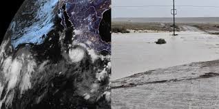
Hurricane Polo: From Tropical Storm to Major Threat
What started as a tropical disturbance has quickly evolved into a serious weather event. Hurricane Polo, which formed off the southwestern coast of Mexico, is currently undergoing rapid intensification. According to the National Hurricane Center (NHC), the storm is expected to escalate into a major hurricane (Category 3 or higher) by Wednesday.
While the center of the storm may remain offshore, the implications of Hurricane Polo extend far beyond the coastlines of Mexico, bringing hazardous conditions to the United States.
Impact on Mexico: Winds and Mudslides
As Hurricane Polo parallels the southwestern and west-central coasts of Mexico, residents are on high alert. The storm is forecast to bring:
- n
- Destructive hurricane-force winds that could cause significant structural damage.
- Dangerous coastal storm surges threatening low-lying areas.
- Torrential rainfall capable of triggering catastrophic mudslides in mountainous regions.
The US Southwest: A Dangerous Flood Threat
Although Hurricane Polo is not expected to make landfall in the United States, its atmospheric influence is already being felt. Moisture from the storm is streaming directly into the US Southwest, supercharging monsoon thunderstorms.
The National Weather Service (NWS) has issued severe warnings for New Mexico, highlighting a significant risk of life-threatening flash flooding. Areas such as Las Cruces, Roswell, and Albuquerque are particularly vulnerable as the flood threat shifts northward and eastward between Tuesday and Thursday.
The “Super” El Niño Factor
The intensity of this season is no coincidence. A rapidly strengthening El Niño has reached nearly 100% odds of achieving “super” status. This phenomenon has effectively supercharged the Pacific basin, leading to an unusually active season with 18 named storms so far, and months of activity still remaining.
Other Tropical Activity: Odalys and Hawaii
Hurricane Polo isn’t the only system causing concern in the Pacific. Meteorologists are closely monitoring two other developments:
- Tropical Storm Odalys: Currently churning southwest of Baja California, Odalys is expected to strengthen into a hurricane. Experts suggest that Odalys and Polo could interact, potentially adding further uncertainty to the forecast and increasing moisture flow into the Southwest.
- Hawaii’s Weather Warning: The remnants of Tropical Depression Fifteen-E are moving toward Hawaii. While it may not fully reorganize into a named storm, it is expected to bring heavy rainfall—potentially 8 to 12 inches—to the Big Island, which is still recovering from previous hurricane damage.
Stay tuned for further updates as these weather systems evolve. Always follow the guidance of local authorities and official weather agencies for evacuation orders and safety protocols.



