
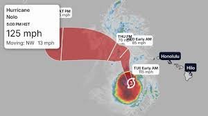
Hurricane Nolo Explodes to Category 4: A Historic Threat to Hawaii’s Big Island
The Pacific is witnessing a terrifying display of nature’s power as Hurricane Nolo has rapidly intensified into a powerhouse Category 4 hurricane. Moving westward into highly favorable atmospheric conditions, the storm has seen its winds surge by a staggering 55 mph in just 24 hours, leaving meteorologists and residents on high alert.
As the system continues its unpredictable path, it threatens to peak as a devastating Category 5 hurricane by Monday. Here is everything you need to know about the current trajectory and the potential impacts on the Hawaiian Islands.
Current Path and Intensity
Hurricane Nolo is currently moving west-northwestward at approximately 12 mph. While the storm is gradually pulling away from the most populated islands, it is not without danger. A hurricane watch is now in effect for the Papahanaumokuakea Marine National Monument.
Forecasts indicate a complex movement pattern: after its peak on Monday, Nolo is expected to weaken slightly, turning northwest and then due north, before making a sharp turn back to the west on Wednesday.
Key Risks for Hawaii Residents
Even as the storm’s center remains offshore, the outer bands are delivering significant threats to the island chain, particularly the Big Island and Maui County.
- n
- Destructive Winds: Wind alerts remain active. Gusts up to 50 mph are expected, with higher risks of power outages and tree damage, especially on mountain slopes.
- Extreme Rainfall & Landslides: With rainfall totals exceeding 14 inches at the highest elevations of the Big Island, the risk of mudslides is critical. Because the soil is already loose on steep terrains, flooding can occur far beyond the areas of heaviest rain.
- Dangerous Surf: Larger swells are generating hazardous surf and strong rip currents across the entire island chain—conditions expected to persist for several days.
A Historic Weather Event
This isn’t just another storm; Hurricane Nolo is breaking records. According to data from the National Oceanic and Atmospheric Administration (NOAA), Nolo represents the strongest impact on the Big Island in 67 years. The last time a storm of this magnitude tracked so close was Hurricane Dot in August 1959.
A Brutal Hurricane Season for Hawaii
Nolo is the fourth system to graze Hawaii this season, compounding an already stressful year for residents. The state has already weathered a series of challenging systems:
- Hurricane Lala: Struck in mid-August, causing massive power outages and torrential rain.
- Tropical Storm Moke: Brought further flooding to already saturated ground.
- Hurricane Lowell: A Category 5 peak storm that slammed the western islands with rain and waves.
With the ground still saturated from previous storms, the threat of flooding and debris remains a primary concern for local authorities. Residents are urged to stay tuned to official weather updates and follow evacuation orders if issued.



