
Houston Weather Alert: Tropical Threat and Heavy Rain Forecast for the Texas Coast
Residents across the Gulf Coast, particularly those tracking Houston weather, should keep a close eye on the horizon this week. A new tropical threat is brewing in the Gulf of Mexico, bringing the possibility of significant rainfall and atmospheric instability to the Texas and Louisiana coastlines.
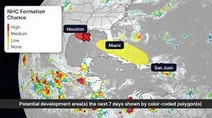
Potential Tropical System ‘Edouard’ on the Radar
The National Hurricane Center (NHC) is currently monitoring an area of low pressure in the Gulf that could develop into a tropical system—potentially named Edouard. While the system is expected to be relatively short-lived, its impact will be felt regardless of whether it officially receives a name.
What to expect in the coming days:
- n
- Heavy Rainfall: Soaking rains are predicted for the first half of the week across the Texas and Louisiana coasts.
- Accumulation: Some areas could see several inches of rain, increasing the risk of localized flooding.
- Active Monitoring: The “Hurricane Hunters” are deployed to fly into the system to gather critical data and refine forecasts.
The Aftermath of Tropical Storm Dolly
While the Gulf faces a new threat, the remnants of Tropical Storm Dolly are creating their own set of challenges. After forming as the fourth storm of the 2026 Atlantic hurricane season, Dolly transitioned into an open tropical wave. However, it is far from gone.
Currently, Dolly’s remnants are bringing beneficial rains to drought-stricken areas of the Caribbean, including Puerto Rico and the Virgin Islands. However, meteorologists are watching for a “second chapter.” Computer models suggest a possibility that Dolly’s “DNA” could redevelop into a tropical system between the Gulf and the western Atlantic later next week, which could potentially bring more moisture to the Southeast United States.
The El Niño Influence: Why Storm Patterns Are Shifting
This year’s weather patterns are being heavily influenced by El Niño. Typically, El Niño enhances storm-killing winds in the upper atmosphere, which often leads to a quieter hurricane season in the Caribbean and tropical Atlantic. This explains why many tropical waves have “fizzled out” recently.
However, if a system can push far enough north, it can escape these suppressive winds and regain strength. This is exactly why monitoring the current Houston weather and Gulf activity is so crucial—even in a predicted “quiet” season, individual systems can still bring significant impacts to land.
Stay Safe: Hurricane Preparedness
Whether a system is a full-blown hurricane or a short-lived tropical depression, the results—such as flash flooding and gusty winds—can be dangerous. Now is the perfect time to review your hurricane safety plan.
Quick Safety Checklist:
- n
- Keep an emergency kit ready with water, non-perishable food, and batteries.
- Stay tuned to official local weather alerts.
- Ensure your drainage systems are clear to handle heavy rainfall.
Stay weather-aware and keep monitoring the latest updates to ensure you and your family remain safe during this active tropical window.



