
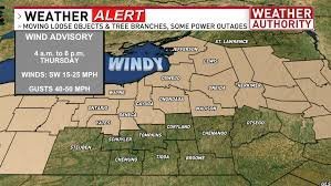
Brace Yourself: High Wind Warning and Severe Weather Heading to Central New York
After a few days of serene and pleasant weather in Syracuse and across Central New York (CNY), the atmosphere is shifting rapidly. Residents should prepare for a volatile weather window starting early Thursday morning, as meteorologists issue a high wind warning and alert the public to potential severe thunderstorms.
The Science Behind the Storm
This sudden turbulence is being driven by a significant pressure clash. A low-pressure system to the west is colliding with a Bermuda high-pressure system situated to the south and east. This atmospheric tug-of-war is creating a high-wind setup that will bring powerful gusts and unstable conditions to the region.
When to Stay Vigilant: The Danger Window
The most critical period for severe weather is expected between 4:00 a.m. and 9:00 a.m. on Thursday. During this time, a warm front will sweep through the area, bringing a cocktail of hazardous conditions:
- n
- Strong Wind Gusts: General high winds from the south and southwest, which can intensify significantly during thunderstorms.
- Severe Thunderstorms: Heavy downpours, frequent lightning, and thunder are expected.
- Tornado Risk: While the region is under a “marginal risk,” the interaction of air moving in different directions could lead to isolated tornado warnings.
- Secondary Threats: Small hail and flash flood warnings are also possible.
Local authorities warn that these conditions could lead to fallen trees and downed power lines, potentially causing widespread power outages across CNY.
Looking Ahead: Sun and Summer Vibes
The good news? The chaos is temporary. By mid-morning Thursday (around 9:00 a.m.), the warm front is expected to clear the area. The sun will return, pushing temperatures up to near 80°F, making for a beautiful, albeit partly sunny, afternoon.
Father’s Day and the Summer Solstice Forecast
If you have outdoor plans for the upcoming weekend, you can breathe a sigh of relief. The forecast for Friday, Saturday, and Sunday looks exceptionally quiet. With the first day of summer arriving at 4:24 a.m., expect:
- Comfortable daytime and nighttime temperatures.
- Mostly sunny skies with occasional clouds.
- Minimal chance of brief sprinkles, ensuring a great Father’s Day celebration.
How to Stay Safe
During a high wind warning, it is essential to secure outdoor furniture and stay indoors during the peak storm window. For real-time updates and official safety protocols, we recommend monitoring the National Weather Service (NWS).
Stay tuned to local news updates to track the movement of these storms and keep your family safe.



