
Heat Dome Alert: How Extreme Temperatures are Fueling Severe Storms and Flooding
While autumn is just around the corner, much of the South and central United States are experiencing a brutal late-season surge in temperature. A massive heat dome has settled over the region, stretching from the Rockies to the East Coast, leaving millions to grapple with oppressive heat and humidity.
In states like Texas, Oklahoma, Kansas, Louisiana, and Arkansas, temperatures have consistently climbed above 100°F. When combined with high humidity levels, the “feels-like” temperature has soared toward 110°F, creating hazardous conditions for residents.
What Exactly is a Heat Dome?
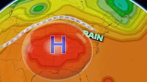
A heat dome occurs when a region of high pressure traps hot ocean air like a lid on a pot. This prevents the warm air from rising and escaping, effectively compressing it and heating it further.
While the daytime highs are alarming, the real concern currently lies in the overnight lows. Forecasters expect temperatures to remain 10 to 15 degrees above average during the night—with some areas seeing a spike of 20 degrees—potentially breaking over 100 record-warm daily low temperatures this week.
The Domino Effect: From Scorching Heat to Severe Storms
The impact of a heat dome extends far beyond just high temperatures. This atmospheric phenomenon is currently acting as a catalyst for severe weather and flooding across the Northeast and Great Lakes regions. This happens through two primary mechanisms:
- n
- Jet Stream Obstruction: The heat dome acts like a massive boulder in the jet stream, forcing the normal flow of air to divert. This pushes severe storms to ride along the edges of the dome, often stalling them over specific areas and leading to catastrophic flooding.
- Temperature Contrast: The sharp divide between the trapped hot air and the cooler air to the north and east creates atmospheric instability. This contrast generates “spin,” which allows developing storms to organize and strengthen rapidly.
Flood Risks and Regional Warnings
Heavy rainfall and flooding threats have already begun to materialize. From Chicago to Detroit, the Midwest has seen significant activity, with moisture tracking toward Pennsylvania, New Jersey, and New York City. Meteorologists warn that 2 to 3 inches of rain are possible in a corridor stretching from the Great Lakes into southern New England.
Further rounds of intense rain and potential flooding are expected to persist through the middle of the week, although the exact location of these cells remains volatile.
The Climate Change Connection
These extreme weather patterns are not occurring in a vacuum. As global temperatures rise due to climate change, the atmosphere is capable of holding more moisture. This increased capacity fuels heavier, more frequent downpours and intensifies the severity of high-pressure systems like heat domes.
Staying informed and prepared for these rapid weather shifts is essential as we navigate an era of increasing climatic volatility.



