Hawaii Flood Watch: Stay Alert as Heavy Rain Sweeps Across the Islands
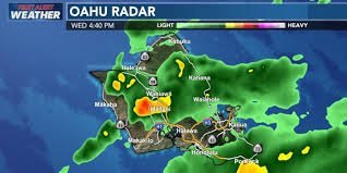
Hawaii on High Alert: Understanding the Current Flood Watch
Residents across the Hawaiian Islands are being urged to remain vigilant as a flood watch remains in effect for several regions. A surface trough shifting over the eastern half of the state has brought a surge of moist air and unstable weather conditions, leading to concerns over minor flooding and ponding in various neighborhoods.
While some areas have seen manageable drizzle, others have experienced significant downpours and thunderstorms, making it crucial for locals and visitors to stay updated on the latest weather alerts.
Which Areas are Under the Flood Watch?
The weather threat is widespread, although the intensity varies by island. Currently, the flood watch is active for the following locations through early Thursday:
- n
- Oahu
- Maui
- Molokai (where some schools were closed Wednesday due to flooded roads)
- Lanai
- Kahoolawe
- Hawaii Island (particularly the Hamakua coast)
Notably, Kauai is no longer under a watch, having received the least amount of rainfall compared to the other islands.
The Science Behind the Storm
The current weather pattern is driven by a broad trough bringing an exceptionally moist airmass from the south. According to meteorological data, the air overhead is holding double its usual moisture, which creates a high capacity for producing sudden, heavy rain bursts.
Interestingly, the actual rainfall totals have been lower than what original weather models projected. This is largely because the upper-level jet and dynamics of the trough weren’t as aggressive as initially feared, sparing some neighborhoods from the extreme downpours previously predicted.
What to Expect Moving Forward
The “First Alert Weather Day” continues into the night, but there is light at the end of the tunnel. Conditions are expected to improve significantly by Thursday or Friday.
Here is the short-term forecast:
- Friday Night into Saturday: A brief return of trade winds.
- Sunday: Breezy northeast winds are expected as a shallow front moves over the state.
- Halloween: Those planning for trick-or-treating should be prepared for some wet weather, especially in windward and mauka neighborhoods.
For real-time updates and official safety warnings, we recommend monitoring the National Weather Service (NWS) to ensure you have the most accurate information for your specific location.
Stay safe, keep an eye on the roads, and remain tuned to local weather alerts to navigate this flood watch period securely.
📰 You May Also Like