Florida Under High-Risk Flood Watch: Record Rainfall and the El Niño Impact
Extreme Weather Alert: Florida’s Atlantic Coast Battles Record-Breaking Floods
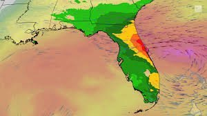
The Sunshine State is living up to a different kind of reputation this November. Residents along Florida’s Atlantic coast, stretching from Ft. Lauderdale to Melbourne, are currently facing a critical flood watch as unprecedented rainfall continues to batter the region. For the second time in less than three weeks, the area has been inundated, smashing seasonal and all-time rainfall records.
The situation has become so severe that the National Oceanic and Atmospheric Administration (NOAA) has placed several regions under its highest risk category for flooding. This isn’t just a typical storm; it’s a meteorological anomaly that is rewriting the history books for the state’s eastern peninsula.
The Magnitude of the Deluge
The impact on the Space Coast and First Coast has been particularly devastating. Some areas between Melbourne and Daytona Beach have recorded a staggering 10 to 20 inches of rain in a single week. The numbers are eye-opening across the board:
- n
- West Palm Beach: 18.25 inches (Record-breaking November)
- Ft. Lauderdale: 15.49 inches (Record-breaking November)
- Vero Beach: 12.32 inches (Record-breaking November)
Beyond the urban centers, the St. Johns River has surged beyond its previous record flood level from October 1953, leading to significant swamping of local neighborhoods. NOAA warns that “high risk” days are dangerous, as nearly half of these events lead to at least one flood-related fatality or injury.
When Will the Rain Stop?
There is a glimmer of hope on the horizon. Meteorologists anticipate that a developing low-pressure system offshore will help displace the stationary rainbands by Saturday. While some locally heavy downpours may still occur, the majority of the state is expected to dry out by Sunday.
However, the most critical area—between Cape Canaveral and the Florida-Georgia border—could still see an additional 3 inches of rain, with some persistent bands potentially dumping over a foot more on already saturated ground.
The El Niño Factor: Why is This Happening?
Typically, October through May marks Florida’s dry season. However, this year, El Niño is flipping the script. This climate pattern amplifies the subtropical jet stream, creating a “storm highway” that funnels moisture from the Pacific across the Southern U.S. directly into Florida.
This shift means the winter months will likely feel more like the peak of thunderstorm season. But the rain isn’t the only concern. The same jet stream introduces wind shear—a change in wind speed and direction with height. This atmospheric instability provides the perfect ingredients for severe weather, including the potential for tornadoes.
Staying Safe During a Flood Watch
When a high-risk flood watch is in effect, safety must be the priority. Residents are encouraged to:
- n
- Avoid driving through flooded roadways (“Turn around, don’t drown”).
- Stay updated via the National Weather Service.
- Prepare emergency kits and ensure drainage systems are clear of debris.
As Florida braces for a wetter-than-average winter, staying informed is the best defense against the unpredictable power of El Niño.
📰 You May Also Like