Florida Flood Warning: El Niño Set to Bring Heavy Rain and Storms
Florida Braces for Heavy Rainfall: Understanding the Current Flood Warning
The “Sunshine State” is about to see a lot less sun and a lot more water. A slow-moving low-pressure system is currently migrating from the eastern Gulf, sweeping across the Florida peninsula, and heading toward the western Atlantic. This atmospheric shift is triggering a significant flood warning for several regions, signaling a volatile end to the week.
What’s Happening in the Atmosphere?
Meteorologists are observing a complex interaction of weather patterns. While sporadic showers and thunderstorms have been present, a disturbance high in the atmosphere is expected to settle over Florida, increasing the coverage and longevity of storms starting Friday.
On the Atlantic Coast, persistent onshore flow—combined with shifting winds aloft—is creating a “congestion” effect. This means storms will likely move slower than usual, dumping massive amounts of rain over the same areas for extended periods, which drastically increases the risk of flash flooding.
Critical Areas and Rainfall Expectations
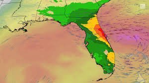
The NOAA (National Oceanic and Atmospheric Administration) Weather Prediction Center has already issued a Level 3 out of 4 flood threat for parts of the Atlantic coast. The primary targets for the heaviest rainfall include:
- n
- Primary Zone: The East Coast, specifically between Jacksonville and Port St. Lucie.
- Expected Accumulation: At least four inches of rain are anticipated, with some unlucky communities potentially seeing over a foot of rain.
The El Niño Effect: A Wet Winter Ahead
Normally, October marks the beginning of Florida’s dry season. However, this year is different. El Niño is altering the traditional weather script, poised to bring rainfall totals more typical of the peak thunderstorm season than a dry winter.
How does it work? El Niño amplifies the jet stream across the subtropics. This creates a “storm highway,” allowing weather systems to travel from the Pacific, across the Southern United States, and directly into Florida.
Beyond the Rain: The Risk of Severe Weather
The concerns aren’t limited to just standing water. The same jet stream responsible for the moisture also introduces wind shear—the change in wind speed and direction at different altitudes. When wind shear is present, it can cause the atmosphere to roll and twist, creating the perfect conditions for severe weather and tornadoes.
As we navigate this unusually wet season, staying informed is your best defense. Keep a close eye on the latest radar updates and NOAA warnings to ensure you and your family remain safe during these volatile weather events.
📰 You May Also Like