
Flood Watch Issued: Prepare for Heavy Rain and Potential Severe Weather
ROCHESTER, N.Y. – A Flood Watch has been issued for Tuesday as the region braces for heavy rainfall and the possibility of strong to severe thunderstorms. While Monday offers a relatively calm start to the week, conditions are expected to deteriorate rapidly.
Monday’s Forecast: A Brief Respite
Monday will be characterized by mostly cloudy skies and mild temperatures, reaching into the 60s Fahrenheit this afternoon. Gusty winds are anticipated later in the day, with a few scattered showers arriving in the late afternoon and early evening. This is a good time to prepare for the more significant weather event expected on Tuesday.
Tuesday’s Yellow Alert: Flood Risk and Severe Thunderstorms
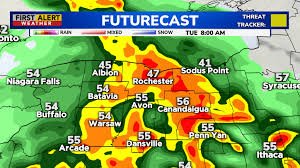
Tuesday’s Yellow Alert is in place due to a combination of factors, with the primary concern being multiple rounds of heavy rain and the potential for localized flooding. Rainfall totals of 1 to 2 inches are likely, with some areas, particularly south of Rochester, potentially receiving even higher amounts.
Beyond the flood watch, the development of thunderstorms is expected, some of which may become strong to severe. These storms could bring gusty winds, frequent lightning, and hail. Expect downpours both overnight into Tuesday morning and again later Tuesday afternoon into the night.
Temperatures on Tuesday will vary, ranging from the 50s near the lake to the upper 60s and low 70s south of the Thruway.
Looking Ahead: Cooler Temperatures and Continued Uncertainty
The weather will turn significantly cooler on Wednesday and Thursday, with a continued chance of showers. Unsettled conditions are expected to persist through Friday into the weekend, although temperatures will begin to warm up later in the week. We can anticipate temperatures returning to near or above 60 degrees Fahrenheit by Friday and Saturday.
Easter Sunday Outlook: A Cold Front Approaches
Looking ahead to Easter Sunday, an approaching cold front warrants attention. Showers are expected to increase, and the timing of the front will determine whether we experience one last warm day or a drop in temperatures during the day. Cooler weather is anticipated to settle in at the start of next week.
Stay tuned to News10 for the latest updates on the rain and thunderstorm threat on Tuesday. For more information on flood safety, visit the National Weather Service’s flood safety page.
Any person with disabilities who needs help accessing the content of the FCC Public file should contact Richard Reingold at rreingold@whec.com or 585-546-1701. This website is not intended for users located within the European Economic Area.
© WHEC-TV, LLC A Hubbard Broadcasting Company


