Earthquake Today: Understanding Seismic Activity and Safety Tips for the US
Earthquake Today: Understanding Seismic Activity and Essential Safety Guidelines in the US
The ground beneath our feet often feels solid and unchanging, but seismic activity can strike without warning. Whether you are tracking a tremor today or living in a high-risk zone, understanding how earthquakes work and how to react can make all the difference between safety and disaster.
What to Do During an Earthquake: Expert Safety Tips
When the earth starts to shake, panic is your worst enemy. According to seismic prevention experts, your immediate actions are critical. If you find yourself in a vehicle during a tremor, follow these steps:
- n
- Stop immediately: Pull over to a clear area.
- Stay clear of hazards: Move away from buildings, trees, overpasses, and utility poles.
- Stay inside the car: Once stopped in a safe spot, remain inside your vehicle until the shaking stops.
For those indoors, the gold standard remains “Drop, Cover, and Hold On.” For more detailed emergency planning, visit Ready.gov.
Sismo, Temblor, or Terremoto: What’s the Difference?
While often used interchangeably, there are nuanced differences in how we describe seismic events:
- Seismic Event (Sismo): A general term for any sudden movement of the Earth’s crust, regardless of its strength.
- Tremor (Temblor): Typically refers to a mild seismic event that causes shaking but does not result in significant structural damage.
- Earthquake (Terremoto): An intense seismic event characterized by powerful waves that cause severe destruction and potential loss of life.
The Most Powerful Earthquake in History
To put these terms in perspective, the strongest earthquake ever recorded occurred on May 22, 1960, in Valdivia, Chile. Reaching a staggering magnitude of 9.5, it triggered volcanic eruptions and a massive tsunami that crossed the Pacific, affecting Japan, Hawaii, and the Philippines, leaving thousands of victims in its wake.
Why the US is Vulnerable: The Ring of Fire
The United States is one of the most seismically active countries in the world. This is primarily due to the “Ring of Fire,” a massive horseshoe-shaped belt in the Pacific Ocean where a large number of earthquakes and volcanic eruptions occur.
High-Risk Zones:
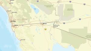
- The West Coast: California, Alaska, and Hawaii are the most prone to severe quakes. Cities like San Diego, San José, and Vallejo are particularly vulnerable due to intersecting geological faults.
- The Interior and East Coast: While less frequent, a recent study by the U.S. Geological Survey (USGS) suggests that nearly 75% of the US territory could experience damaging earthquakes. This includes cities like New York, Boston, and Philadelphia.
How Do We Measure the Shaking? Magnitude vs. Intensity
Science has evolved in how it measures the energy released during a quake. You might have heard of the Richter Scale, but today, experts use more precise tools:
1. Moment Magnitude Scale (Mw)
Introduced to replace the Richter scale (which struggled with very large events), this scale measures the total energy released. It is the current standard for calculating the size of major earthquakes.
2. Modified Mercalli Scale (MM)
Unlike magnitude, the Mercalli scale measures intensity. Using Roman numerals (I to XII), it describes the actual effects on people and buildings, which vary depending on the distance from the epicenter and the soil quality.
Stay informed and prepared. By understanding the science and the safety protocols, you can better navigate the unpredictable nature of our planet.
📰 You May Also Like